|
|
Post by Benfxmth on Oct 24, 2023 12:43:32 GMT -5
|
|
|
|
Post by greysrigging on Oct 24, 2023 21:13:24 GMT -5
Lovely spring day in Adelaide...   t's an extremely chilly Wednesday in Adelaide by late October standards with the mercury cautiously edging up to a predicted top of just 15°C, but unfortunately there's not much rain accompanying the unseasonable cold. "I can confirm that a hoodie wasn't enough for my morning coffee run," Adelaide-based meteorologist Stephen King said around 11 am local time, when the city's apparent or "feels like" temp was just 7.7°C. You can see the surge of cold air pushing northwards over southern parts of South Australia in the three-hour loop to 9:10 am morning.  While light showers are occurring across southern SA from about the Yorke Peninsula eastwards, there's not enough moisture with this system to generate significant rainfall. Overnight, falls were only in the vicinity of a millimetre or two at most weather stations in the southeast, with similar readings expected today. Some spots have missed out entirely on rain in this system as at 10:30 am local time, including Adelaide's "official" weather station at West Terrace/ngayirdapira and most other nearby stations, which is bad news for the city’s parched parks and gardens. Take a look at the 12-month rainfall graph for Adelaide.  After a relatively wet first half of the year, the last four months have all had significantly below-average rainfall – and there's almost no rain expected between now and the end of the month. Further afield in Victoria, the cold air has also arrived this Wednesday, with Melbourne likely to reach just 14°C - its coldest day since October 4. Like the southeast of SA, southern and central Victoria likely won't see big rainfall totals from this event. This cold airmass is well and truly cold enough for snow in the mountains with an 11 am temperature of -1.4°C at kunanyi/Mt Wellington above Hobart and -1.8°C at Mt Buller, northeast of Melbourne. But again, lack of significant moisture means that Victoria has so far dodged the flakes and it’s completely sunny in the Snowy Mountains of NSW. However snow has fallen in parts of Tasmania, as evidenced by the live cam at Mt Mawson, about two hours west of Hobart.  |
|
Deleted
Deleted Member
Posts: 0
|
Post by Deleted on Oct 25, 2023 0:44:31 GMT -5
|
|
|
|
Post by MET on Oct 25, 2023 8:49:53 GMT -5
|
|
|
|
Post by Steelernation on Oct 25, 2023 11:55:30 GMT -5
Reached 84 (29 c) again on the 20th, again the latest it’s been that warm outside of 2003.
October is averaging 72.9/40.0 so far which makes it the 4th warmest October to date. The cold snap coming up will drop those averages a lot though.
Unfortunately it looks like below average weather will stick around for awhile after the coldest days. I’m looking forward to the 30s and snow this weekend but the 40s/low 50s and sunny after can fuck off.
|
|
|
|
Post by Beercules on Oct 25, 2023 15:22:20 GMT -5
lmao if no one died, I guess it would be a "normal" fog.
God I hate the media.
|
|
|
|
Post by greysrigging on Oct 25, 2023 15:54:56 GMT -5
Decent diurnal range un Renmark the other day....  |
|
|
|
Post by greysrigging on Oct 25, 2023 19:43:50 GMT -5
|
|
|
|
Post by Marcelo on Oct 26, 2023 8:48:38 GMT -5
Otis was a mere tropical storm on Tuesday and no model expected it to become a hurricane. 24 hours later it had turned into a Category 5 monster that destroyed Acapulco. There is massive damage everywhere; not much info about the people affected yet.
|
|
|
|
Post by Steelernation on Oct 26, 2023 23:05:35 GMT -5
Today was the coldest day since April, high was only 45 (7 c) with mist all day. I like this weather though, felt refreshing and cozy. Fall colors are now past peak and there’s even some bate trees.
|
|
|
|
Post by Ariete on Oct 27, 2023 6:58:29 GMT -5
First snow for Turku. Not much did stick, some on roofs, car windows and bushes.
|
|
|
|
Post by Beercules on Oct 27, 2023 21:50:04 GMT -5
Can anyone say "mongoloid" !  |
|
|
|
Post by greysrigging on Oct 28, 2023 2:47:21 GMT -5
Onslow Airport ( WA Pilbara ) running at an astonishing +6c mean max for Oct ( so far )  The last 18 days...  I worked there in 1999... Oct '99 wasn't like in Oct 2023....  |
|
|
|
Post by MET on Oct 29, 2023 8:20:47 GMT -5
First major windstorm which will bring 100mph / 160kph winds to the south-east coast. My dad, living on the SE tip of England, needs to watch out, in-case he gets blown into the sea. I hope he can swim good.  |
|
|
|
Post by Cheeseman on Oct 29, 2023 8:44:12 GMT -5
Otis was a mere tropical storm on Tuesday and no model expected it to become a hurricane. 24 hours later it had turned into a Category 5 monster that destroyed Acapulco. There is massive damage everywhere; not much info about the people affected yet. 2nd fastest intensification on record for the Eastern Pacific. I thought Norma was going to be the big one, and then Otis just came out of nowhere. Goes to show we really need to improve our models if they're completely blowing forecasts like this and people keep getting caught off guard by category 5 hurricanes. I'm also surprised there's been no discussion of the big snowstorm in the northern plains here in the US. 14.0" (35.6 cm) in Glasgow, MT over three days (most of it this past Wednesday), enough to make it the snowiest season on record up to this point! Here in Madison, the high was 69 F (21 C) on Friday before a strong cold front came through and yesterday's high was only 41 F (5 C). Today is supposed to be similar, and then even colder tonight through Tuesday with potentially our first snow of the season. |
|
|
|
Post by Benfxmth on Oct 29, 2023 8:46:22 GMT -5
Otis was a mere tropical storm on Tuesday and no model expected it to become a hurricane. 24 hours later it had turned into a Category 5 monster that destroyed Acapulco. There is massive damage everywhere; not much info about the people affected yet. 2nd fastest intensification on record for the Eastern Pacific. I thought Norma was going to be the big one, and then Otis just came out of nowhere. Goes to show we really need to improve our models if they're completely blowing forecasts like this and people keep getting caught off guard by category 5 hurricanes. I'm also surprised there's been no discussion of the big snowstorm in the northern plains here in the US. 14.0" (35.6 cm) in Glasgow, MT over three days (most of it this past Wednesday), enough to make it the snowiest season on record up to this point! Here in Madison, the high was 69 F (21 C) on Friday before a strong cold front came through and yesterday's high was only 41 F (5 C). Today is supposed to be similar, and then even colder tonight through Tuesday with potentially our first snow of the season. Hurricane intensity foreskincasts need improvement, but overall they've been getting better over the years: |
|
|
|
Post by rozenn on Oct 29, 2023 10:45:36 GMT -5
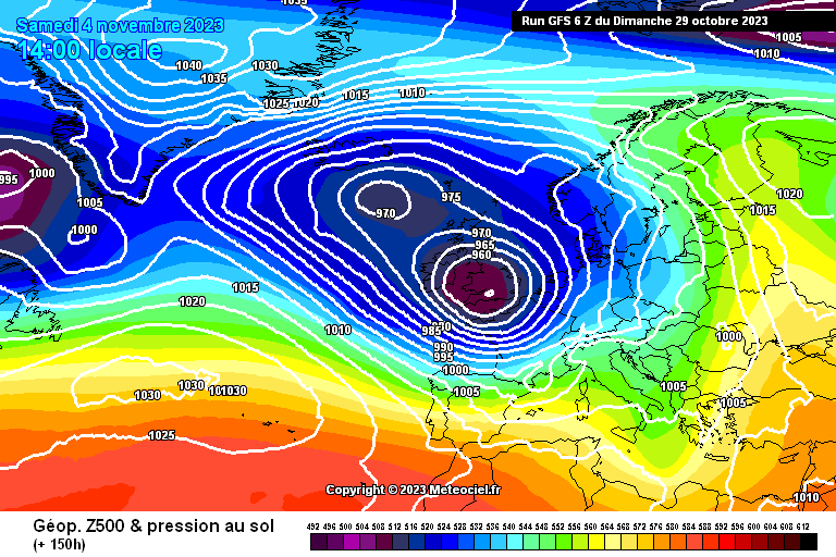
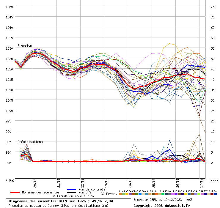
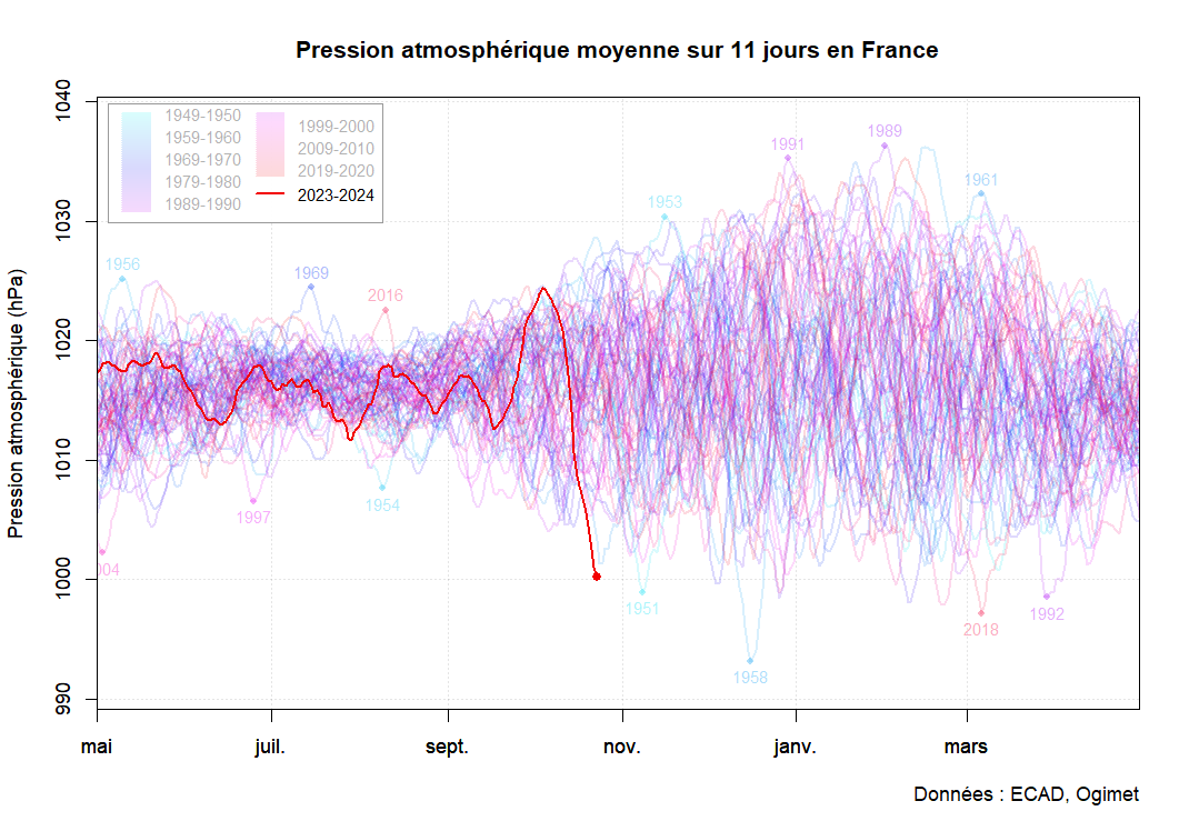
Impressive mean pressures on ensembles for Thursday and Saturday. More or less the same on all models, here the GFS   Lol @ the diagrams for the Channel. Rediculous.  The 2-week pressure anomoly at the end of the week will be something to behold, as it's already at record levels for the season:  |
|
|
|
Post by Steelernation on Oct 29, 2023 12:52:26 GMT -5
First snowfall yesterday, 3.5” (9 cm) was recorded as of 7 PM but more fell since so likely 4-5” total. Nice fall for October.
Also had an ice day yesterday, high was just 30 (-1 c). Similarly cold today before average temps return by mid week.
|
|
|
|
Post by ral31 on Oct 29, 2023 19:09:33 GMT -5
Very warm this past week with temps in the upper 80's to 90F (which was reached Oct 24). On the humid side as well since the middle of last week. 87F today, then strong front to arrive by daybreak tomorrow. Looking like temps may drop to the upper 40's in the afternoon with showers! Clearing up Halloween but temps may not reach 60F Tuesday or Wednesday. First freeze of the season is being forecast Wednesday night (31F currently)!
Unfortunately rainfall tomorrow looks light, so not much drought relief.
|
|
|
|
Post by Marcelo on Oct 30, 2023 10:54:27 GMT -5
Intense cold front affected Patagonia last weekend, but more importantly, a lot of humidity involved, so there was an unusual snow accumulation in the Andes region. Bariloche was -0.3C/3.5C yesterday. Esquel was -1.4C/5.3C. In both cases, daily highs occurred at the beginning of the day. It's been snowing up until a couple of hours ago.
Not bad at all considering we're about to enter November:
Bariloche:
Esquel:
|
|