|
|
Post by greysrigging on Oct 30, 2023 19:51:41 GMT -5
Wild, Wndy, Weird, Warm Night ( source: Weatherzone )  It was a wild night of temperature contrasts across southeastern Australia, with a wave of warm air baking eastern NSW well into the small hours, wild winds buffeting Sydney, and snow blanketing elevated parts of southern Victoria and Tasmania Let's start with the warm air. As we've seen a couple of times already this spring, the Sydney region was the bullseye for the warmest air moving across the southeast. For example: At 3 am, it was 28°C at Sydney Airport At 3 am it was 16°C at Brisbane Airport At 3 am it was 8.4°C at Melbourne Airport The orange arrow near Sydney on Weatherzone's 5 am synoptic chart does a good job of showing why the night was so warm, with warm air from Australia’s northern interior funnelled towards the city and nearby areas.  It was actually a very unusual night in Sydney, and here's why: Some suburbs in the city's west reached their minimum temperature before midnight, after which the wind picked and brought a fresh surge of warmth. Normally you'd expect the min temp just after dawn. For example, Penrith had its minimum of 23°C at 9 pm. Temperatures then jumped back up into the mid-twenties for the rest of a wild, windy, very warm night. It was also extremely windy, with a gust of 104 km/h just after 4 am at Badgerys Creek in the city's west, the strongest gust in any month since 2006. Badgerys Creek is of course home to Sydney's second major airport currently under construction, but the existing airport on the shores of Botany Bay was also lashed by winds up to 80 km/h, disrupting early morning air traffic. Whenever there's a surge of warm northwesterly air across eastern NSW in springtime, you can bet that the engine driving it is a low pressure somewhere way down south. Just such a system, and the cold front associated wiht it, were indeed the culprits – and the front caused big temperature drops in Melbourne as it passed through early on Monday evening. There wasn't widespread moisture associated with the cool change, but an impressive line of quick-moving storms crossed southern Victoria late in the day, delivering 1.8 mm of rainfall to Melbourne, 5.6 mm to Geelong, and a few falls of 10 mm or slightly higher in Gippsland.  Speaking of Gippsland, it's snowing up at Mt Baw Baw this Tuesday morning but nowhere else on the Australian mainland. Baw Baw is mainland Australia's lowest ski area, but it's also the southernmost. That southern location means that occasionally in spring it will see snow that doesn't make it to the higher peaks of northern Vic or southern NSW. As mentioned at the top of this story, Tasmania also saw some light snowfalls overnight.  |
|
|
|
Post by greysrigging on Nov 1, 2023 1:01:50 GMT -5
'Australia's hottest place' almost 6 degrees above average in October ( source: Weatherzone )  Onslow, a coastal town in Western Australia's Pilbara region with a population of around 900, holds half of a significant Australian heat record – equalling Australia's highest recorded temperature when the mercury reached a searing 50.7°C in January 2022. On average, Onslow is not quite as hot as several other WA towns such as Marble Bar, which sits 200 km inland from the Pilbara coast, but it's still plenty hot enough, and the heat in October 2023 was quite remarkable. In October 2023, Onslow's average maximum was a whopping 5.7°C above the long-term monthly average from 1943-2023. Onslow's long-term average max in Oct is 32.9°C Onslow's average max in Oct 2023 was 38.6°C The remarkable anomaly of almost six degrees was caused by higher-than-normal air pressure which lingered over central Australia during October due to the active El Niño and positive IOD. This directed persistent southeasterly winds to the Pilbara coast, pushing hot desert air to the coast and delaying sea breezes most days.   ( ^^ my photos of Onslow in 1999 ) Meanwhile across Australia, October average maximum temperatures were much warmer than usual in almost all areas, with seven of the eight capital cities recording above-average max temps. The list below shows how far each capital city’s October 2023 max temps were above or below the long-term monthly average: Sydney +3.5°C (3rd-hottest Oct on record for max temps) Perth +2.9°C (2nd-hottest Oct on record for max temps) Darwin +1.3°C Hobart +1°C Canberra +0.7°C Brisbane +0.5°C Adelaide +0.1°C Melbourne -0.5°C If you're in Melbourne and you thought October was a little chilly overall, even by local standards, you're right. |
|
|
|
Post by Beercules on Nov 1, 2023 14:41:46 GMT -5
DISGUSTING. PURE FUCKING RAGE. THAT, THAT IS WHAT A PISS TAKE LOOKS LIKE.
|
|
|
|
Post by srfoskey on Nov 1, 2023 18:25:19 GMT -5
We had a major cold front come in on Friday evening, and then Saturday and Sunday were cold and rainy. Sunday did not get above 38°F (4°C), which is very unusual for October. It was rainy all day, but there was no frozen precip. I'm thankful it was milder than it was in late October 2020, when we had an ice storm. Either way, Sunday was one of a very few days in Oklahoma that I thought was too cold for the season. We also had hard freezes the past couple of nights, and I remembered to take my plants in beforehand. This weekend temperatures should warm back up to near-normal.
|
|
|
|
Post by rozenn on Nov 1, 2023 19:32:56 GMT -5
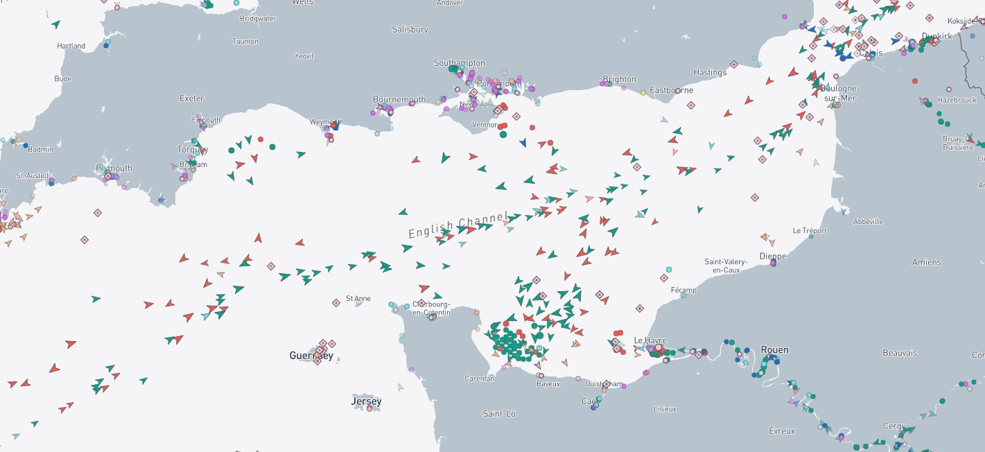
Very low pressure rn between Brittany and Cornwall under storm Ciaran, at 954 hPa. To date highest gusts a bit above 170 km/h and mean winds of ~130 km/h there. The sting jet associated with the occluded front has Stille not reached land though. Southbound ships are seeking shelter downwind from the Cotentin peninsula in Normandy:  |
|
|
|
Post by greysrigging on Nov 2, 2023 3:03:08 GMT -5
Some chilly late spring ( Nov ) records set in far North QLD and southern NSW yesterday.  |
|
|
|
Post by Speagles84 on Nov 2, 2023 8:43:03 GMT -5
|
|
|
|
Post by greysrigging on Nov 2, 2023 16:34:11 GMT -5
Western Australia's Driest October On Record ( source: Weatherzone )  It was dry across Australia in October, but Western Australia did it tougher than the rest, with its driest October on record. Nationally, it was Australia's 5th-driest October since national records began to be kept in 1900. It was also the 5th-driest October in South Australia, the 6th-driest in the Northern Territory, and the 12th-driest in Queensland.  The map above tells the tale. Of the eight states and territories, only Victoria had slightly-above-average rainfall for the state as a whole – with 8% more rain than the long-term average. That was mainly due to a few active cold fronts in the state's south, and one particularly heavy rainfall event in the first week of the month which caused severe flooding in parts of Gippsland and minor-to-moderate flooding elsewhere. The main other rain event worth mentioning was one heavy night of rain on parts of the NSW Mid North Coast (indicated by a small blue zone on the map). Otherwise, the rest of the country saw few newsworthy rain events and as mentioned, Western Australia suffered the biggest shortfall, due in large part to the positive Indian Ocean Dipole. Take a look at the graph below. It shows how Perth endured its fourth month in a row of significantly below-average rainfall, with 8.2 mm of rain compared to its October average of 39.7 mm.  And Perth was far from alone in being parched in October. Normally soggy Albany in the state's South Coastal forecast district had 23.2 mm compared to its October average of 78.2 mm Geraldton in the state's Central West forecast district had just 1.2 mm compared to its October average of 18.9 mm. Kalgoorlie in the Goldfields district had 0.6 mm compared to its October average of 15.8 mm The fact that Perth, Albany, Geraldton, and Kalgoorlie all had major rainfall deficiencies indicates how dry the southern half of the state was in October 2023. In most cases, the rainfall deficiencies were ongoing from about July too. That's not good news as we head into the usually dry summer in WA's south. Meanwhile Perth is heading for a dry, windy day with a top of 37°C this Friday, which would be the hottest day of spring 2023 to date. |
|
|
|
Post by psychedamike24 on Nov 3, 2023 0:23:50 GMT -5
 Microsoft Start Weather being trippy |
|
|
|
Post by Marcelo on Nov 3, 2023 6:24:38 GMT -5
The explosive drop (and then rise) of the air pressure, as well as how it shows the gusts peaking around the time of passage of the cyclone, make this table a piece of beauty. Peak gust 155 km/h = 43 m/s = 96 mph = 84 kt
|
|
|
|
Post by rozenn on Nov 3, 2023 8:59:46 GMT -5
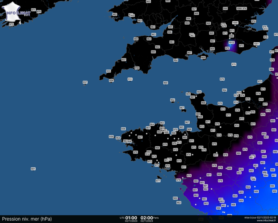
Ciaran was impressive in western Brittany.  Rediculous Beautiful. Waves up to 21 m high have been recorded in SW Brittany. Tornado touchdown in Jersey 954 mbar near Lizard point  Instantaneous wind values up to 207 km/h (129 mph) at the Pointe du Raz. Up to 108 km/h (67 mph) in the Paris Area; 141 km/h (88 mph) at the top of the Eiffel tower.  |
|
|
|
Post by desiccatedi85 on Nov 3, 2023 12:45:08 GMT -5
rozenn fucken epic storm. Can you post some rainfall maps for Western Europe?
|
|
|
|
Post by rozenn on Nov 3, 2023 22:30:30 GMT -5
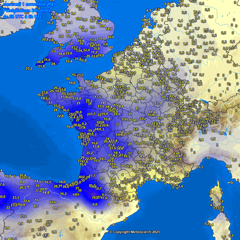
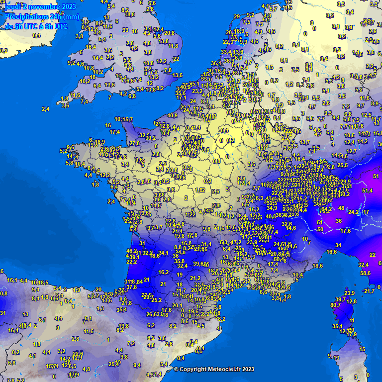
rozenn fucken epic storm. Can you post some rainfall maps for Western Europe? Nothing much really, at least for France, though there has been some flooding in northern France as the rain fell on already saturated soil. Here are maps for the 2nd and 3rd of Nov. As you can see nothing out of the ordinary:      |
|
|
|
Post by AJ1013 on Nov 4, 2023 7:05:51 GMT -5
Absolutely disgusting forecast for the next week here. Very hot and rainy/humid. Dry season my ass:  |
|
|
|
Post by ral31 on Nov 5, 2023 9:27:58 GMT -5
Quite a cold snap late last week. Got down to 27F this past Thursday morning! Broke previous record low of 30F for that date.
High temps now back in the low 80's though humidity is on the low side. Mid 80's coming the middle of the week with an increase in humidity. Frontal system the end of the week should bring more seasonal temps and hopefully a decent rainfall.
|
|
|
|
Post by Steelernation on Nov 5, 2023 22:07:59 GMT -5
77 (25 c) today, very warm for November. Most likely the highest temp until March or April. Looks like a few more warm days before below average to average temps come back.
|
|
|
|
Post by Babu on Nov 6, 2023 2:56:29 GMT -5
September had a mean of 12.1'C and October a mean of 1.4'C. I don't think I've ever experienced such a large difference between two adjacent monthly means before.
|
|
|
|
Post by desiccatedi85 on Nov 6, 2023 15:50:32 GMT -5
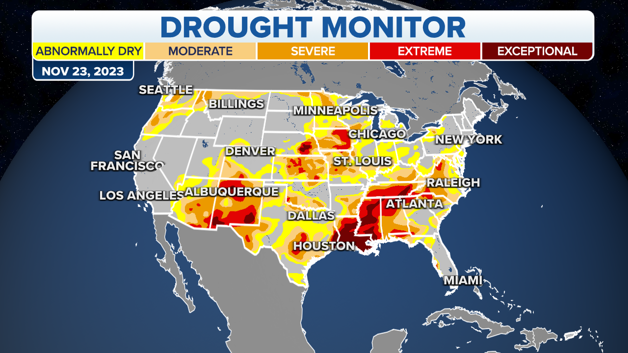
Drought effects showing here. No rain has fallen since October 21, 1.78" since September 18, and still under 4" total since August 16. New bout of warm, dry, windy conditions has wildfires raging in north Georgia and SW North Carolina, especially near Asheville. First rain in a while is forecast for the weekend, let's hope it pans out now that it's November.
|
|
|
|
Post by Steelernation on Nov 6, 2023 18:11:48 GMT -5
New bout of warm, dry, windy conditions has wildfires raging in north Georgia and SW North Carolina, especially near Asheville.
Finally some areas with good scenery opening up |
|
|
|
Post by greysrigging on Nov 7, 2023 0:02:19 GMT -5
Spring has spung in Melbourne:  |
|


