|
|
Post by rozenn on Sept 12, 2023 9:08:36 GMT -5
Double fuckup today as per usual. Even Plaisir got Renmarked. When Plaisir gets Renmarked, you know it's bad. They got some action today tho. Only moderate rain here unfortunately. 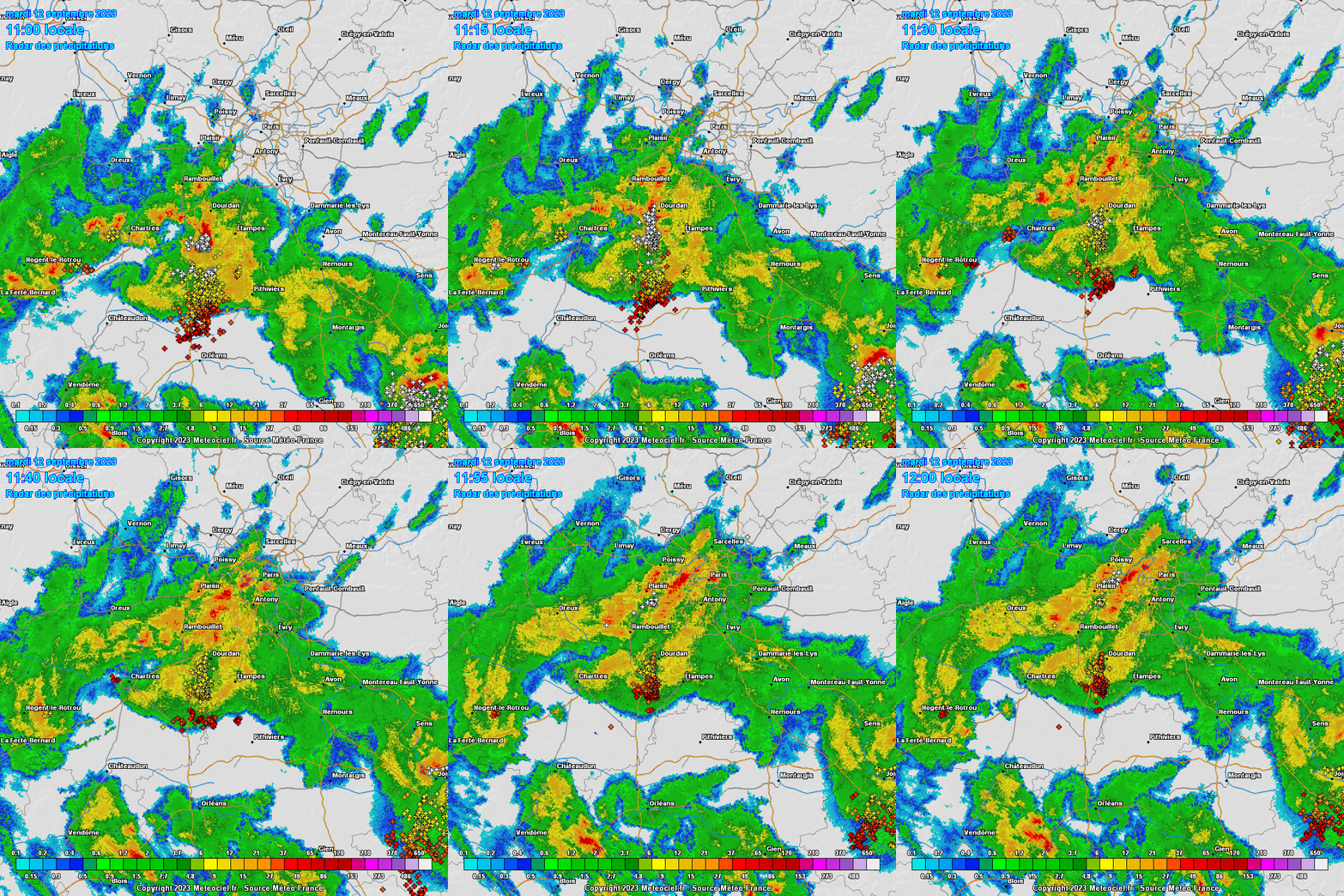 |
|
|
|
Post by Ariete on Sept 12, 2023 23:04:34 GMT -5
Only 7.7 mm of rain this month. Feels weird after the very wet last half of August.
|
|
|
|
Post by greysrigging on Sept 13, 2023 3:56:56 GMT -5
|
|
Deleted
Deleted Member
Posts: 0
|
Post by Deleted on Sept 13, 2023 4:17:58 GMT -5
|
|
|
|
Post by Benfxmth on Sept 13, 2023 14:13:42 GMT -5
Fuck me sideways...I just wanked myself. Been getting 5"+/hr rainfall rates and epic CG lightning with crackling gunshot thunder with these, today didn't disappoint in the slightest bit   |
|
|
|
Post by Ethereal on Sept 13, 2023 18:39:10 GMT -5
Love it. Sydney is pulling a Perth this week, and Perth is pulling a...Melbourne?  |
|
|
|
Post by greysrigging on Sept 13, 2023 20:35:26 GMT -5
CAMBEN, NSW forecast ( just coming out of winter  CAMDEN, NJ forecast ( just coming out of summer )  |
|
|
|
Post by rozenn on Sept 14, 2023 4:54:10 GMT -5
456.4 mm / 18" of rain MTD at Hong Kong airport and counting. Plz send some of that useless rain to France.  |
|
|
|
Post by greysrigging on Sept 14, 2023 14:36:06 GMT -5
Record September warmth in Aussie Alps ( source: Weatherzone )  Several areas in the Australian Alps just had their warmest September day on record, with temperatures soaring more than 10ºC above average at some of Australia's highest weather stations. Abnormally warm air originating over the Australian interior was driven towards the Alps on Thursday as northerly winds developed ahead of an approaching cold front.  This warm air mass caused temperatures to reach 18ºC at Perisher Valley in NSW and over 16ºC at Falls Creek and Mt Baw Baw in Vic. These maximums were about 11ºC above average for a September day. Perisher Valley’s 18.0ºC just before 11:30am was its highest September temperature on record, with data for the current weather station dating back to 2010 and an old station extending back to 1976. Falls Creek’s 16.2ºC and Mt Baw Baw’s 16.7ºC were also new September records, with data from these stations available back to 1990 and 1997, respectively. Mount Buller also warmed to 15.3ºC, which is just over 10ºC above average for this time of year and its warmest September day since 1987. Thursday’s unseasonable alpine warmth follows a lacklustre snow season in the Australian Alps. The peak snow depth measured at Spencer’s Creek in NSW was 131 cm all the way back on July 13. This is the site’s lowest peak snow depth since 2006 and the earliest measured seasonal peak depth in records dating back to 1954. |
|
|
|
Post by Ariete on Sept 15, 2023 0:32:50 GMT -5
Very cold night in large parts of the country:
|
|
|
|
Post by kronan2 on Sept 15, 2023 10:00:25 GMT -5
|
|
|
|
Post by Ariete on Sept 15, 2023 10:05:24 GMT -5
Seems to be a typical frost hollow. Valley, bog, sparse forest. Elevation is 217 m ASL so that is not a factor. The hills are around 400 m.
|
|
|
|
Post by Beercules on Sept 15, 2023 11:22:19 GMT -5
If this actually happens...  |
|
|
|
Post by srfoskey on Sept 15, 2023 14:26:09 GMT -5
We've had highs in the 70s F (low-mid 20s C) the entirety of this work week. That's after having not had a high below 85°F (29.5°C) since July. This cooler air has been a welcome relief. It's also been between partly cloudy and overcast this whole time. That has been a nice break from constant sunshine.
|
|
|
|
Post by greysrigging on Sept 16, 2023 15:54:39 GMT -5
Sun Increasing Towards The Equinox ( source: Weatherzone )  If you’ve been outside recently in the evening, you’ve likely noticed that the sun is setting later and later. Each day during the month of September, locations across Australia have been gaining sunlight, at around 30-40 seconds per day in the far north (including Darwin) to about 3 minutes per day in the far south (about Hobart). This comes as no surprise, as the spring equinox is fast approaching. During equinoxes, the days and nights are of about equal length and the phenomenon occurs twice a year - once in autumn (between 19 and 21 March) and once in spring (between 21 and 24 September). This year, the spring equinox will fall on 23 September, which happens to be next Saturday. Inspired by Brian Brettschneider, an Alaskan climatologist who creates a plethora of interesting weather data maps including local sunset times on the fall equinox (found here), a similar map has been created for Australia using data from the NOAA Solar Calculator.  ^^Figure: Sunset times around Australia (local time) during the spring equinox, occurring on September 23rd, 2023 (NOAA Solar Calculator, Global Monitoring Laboratory, 2023). Towards the eastern side of local time zones, the sun logically tends to set earlier, as seen in the far eastern part of Western Australia, excluding the Australian Central Western Standard Time (ACWST), detailed here. Conversely, on the western side of time zones, the sun tends to set later. With parts of western Queensland, New South Wales, Victoria, South Australia and the Northern Territory having the sun set as late as 7:00pm. Naturally, as spring approaches, the Ultraviolet (UV) Index is beginning to increase, with a few capital cities already in the High UV Index range.  And the daily sunshine hours, too, look to be increasing. Whilst daylight hours are defined by when the sun is above the horizon, sunshine hours are influenced by this as well as cloud cover. Parts of the dry interior and far north tropics, still being in the dry season, are expecting over 10 sunshine hours during the month. Parts of the south, however, are still bearing the brunt of the passage of cold fronts, so sunshine hours could still be as low as 4-5 hours, especially around Tasmania & south coastal Victoria.  Keep an eye out for more information about the upcoming equinox next week. It won't be long until sunset will be much later as daylight savings time is due to start on Sunday, October 1st at 2am, when clocks will go forward one hour. So if you enjoy the evening darkness, soak it up while you can! |
|
|
|
Post by Crunch41 on Sept 16, 2023 21:42:13 GMT -5
Since the 7th there has been a great stretch of fall weather. Highs in the 60s and 70s, some rain on the 11th, thunderstorms on the 12th and 16th, a mix of clouds and sun. Overall very comfortable weather. The first few days were hot with 95F/35C on the 3rd, I don't want that to come back. Fall can stay for good now. There is a warming trend coming so there might be a few 80's left, but high 80's and 90's should be done until May or June. The latest 90F was September 29th in Milwaukee, October 13th in Madison.
It's early for freezing temps, and nowhere in the area has reached freezing yet. The average date for first freeze is early October for rural areas and late October for Milwaukee and areas near Lake Michigan. The coldest temps in the region so farare high 30's, Madison reached 42F/6C, Milwaukee airport only 53F/12C.
|
|
|
|
Post by Ethereal on Sept 17, 2023 1:42:03 GMT -5
The Bureau of Meteorology has issued a severe heatwave warning for parts of the South Coast and Illawarra districts of NSW.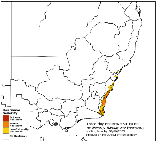 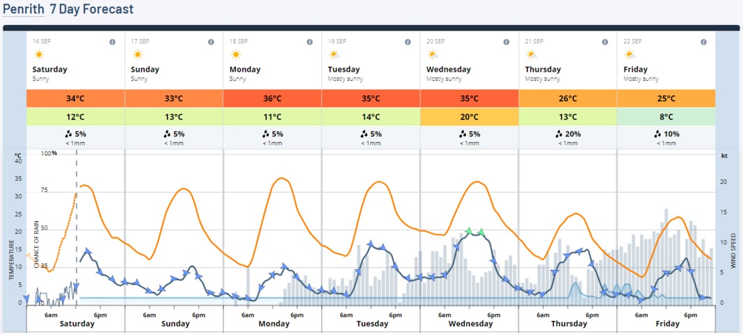
This means that daytime and evening temperatures for these locations are going to be high, even by summer standards, over the following three days; from Monday 18th to Wednesday 20th. Australia is no stranger to heatwaves during summer, especially in the midst of a building El Niño and positive Indian Ocean Dipole event. However, this current warning has been issued approximately two weeks ahead of when the Bureau’s heatwave services officially open, and well before NSW typically see their first heatwave. As suggested in a previous story, the unseasonably warm temperatures expected in the next few days have ticked all the boxes which warrant for a heatwave warning to be issued for southeastern NSW. Warmth is spreading across Australia's centre and southeast while cold fronts slip away, allowing heat to build into near-record highs for this early in the season. Many places across South Australia, Tasmania, Victoria, the ACT and New South Wales have already experienced their warmest spells for this early in the season in 10-20 years. It has been the warmest September spell in:
79 years in Victoria's Essendon (averaging a maximum of 24.2 degrees in the five days to Saturday 16th)
36 years in Victoria's Tullamarine and SA's Mt Gambier (averaging a maximum of 24.2 degrees in the five days to Saturday 16th, and 23.8 degrees in the three days to Thursday 14th respectively)
27 years in NSW's Bombala (averaging a maximum of 23.0 degrees in the four days to Saturday 16th)
24 years in Tasmania's Smithton (averaging a maximum of 18.1 degrees in the four days to Friday 15th)
22 years in Victoria's Falls Creek and Mt Buller (both averaging a maximum of 12.9 degrees in the three days to Thursday 14th and Saturday 16th respectively)
17 years in SA's Port Lincoln (averaging a maximum of 26.1 degrees in the five days to Friday 15th)In Sydney's 165-year history of temperature recordings, Observatory Hill has only ever strung together two 30-degree days in September, most recently in 2014. With the arrival of the warming winds, the city has a few chances to set a new September record between now and Wednesday. Cooling afternoon sea breezes are a high chance on Sunday and Monday making these two days a bit iffy regarding 30 degrees.
However, western suburbs will get little or no afternoon cooling from these sea breezes, making 30 degrees a relative cinch. in 80 years of records, Richmond has had as many as four consecutive 30-degree days in September, most recently in 2013, and should manage five between now and Wednesday.
This unseasonably long and warm spell has largely been due to a positive Indian Ocean Dipole (IOD) and a split jetstream favouring a blocking high-pressure area. The positive IOD has led to skies being generally cloud-free in northwestern Australia, allowing heat to build as a blocking high over the Tasman Sea deflects cold fronts south of the mainland. This setup has meant some of the heat filtered to the country's southeast in persistent northerly winds, causing the region to steadily heat up with minimal interruption.[i/]
www.weatherzone.com.au/news/heat-spreading-across-australias-southeast-a-chance-to-break-records/1509049
www.weatherzone.com.au/news/first-heatwave-warning-issued-ahead-of-the-start-of-the-season-/1511155
|
|
|
|
Post by chesternz on Sept 17, 2023 6:50:29 GMT -5
Pretty typical monsoonal week - relatively cool and cloudy with a couple of significant falls: 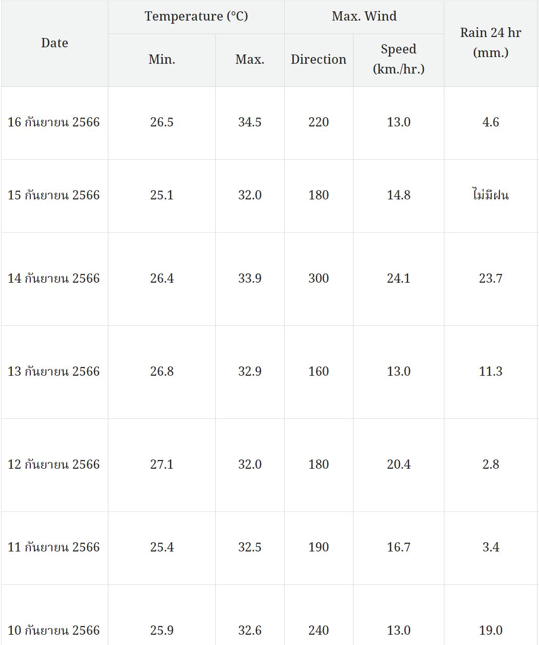 |
|
|
|
Post by greysrigging on Sept 17, 2023 15:09:29 GMT -5
The forecast at my mother's place in Camden, NSW ( 70klm s w of Sydney CBD )  Getting right up there ( record territory..... )   The forecast temps are reached, it would be 6 consecutive days of low to mid 30's heat. Would be a decent run in January, let alone pre Equinox September !! |
|
Deleted
Deleted Member
Posts: 0
|
Post by Deleted on Sept 17, 2023 20:08:17 GMT -5
16mm/0.63" yesterday afternoon 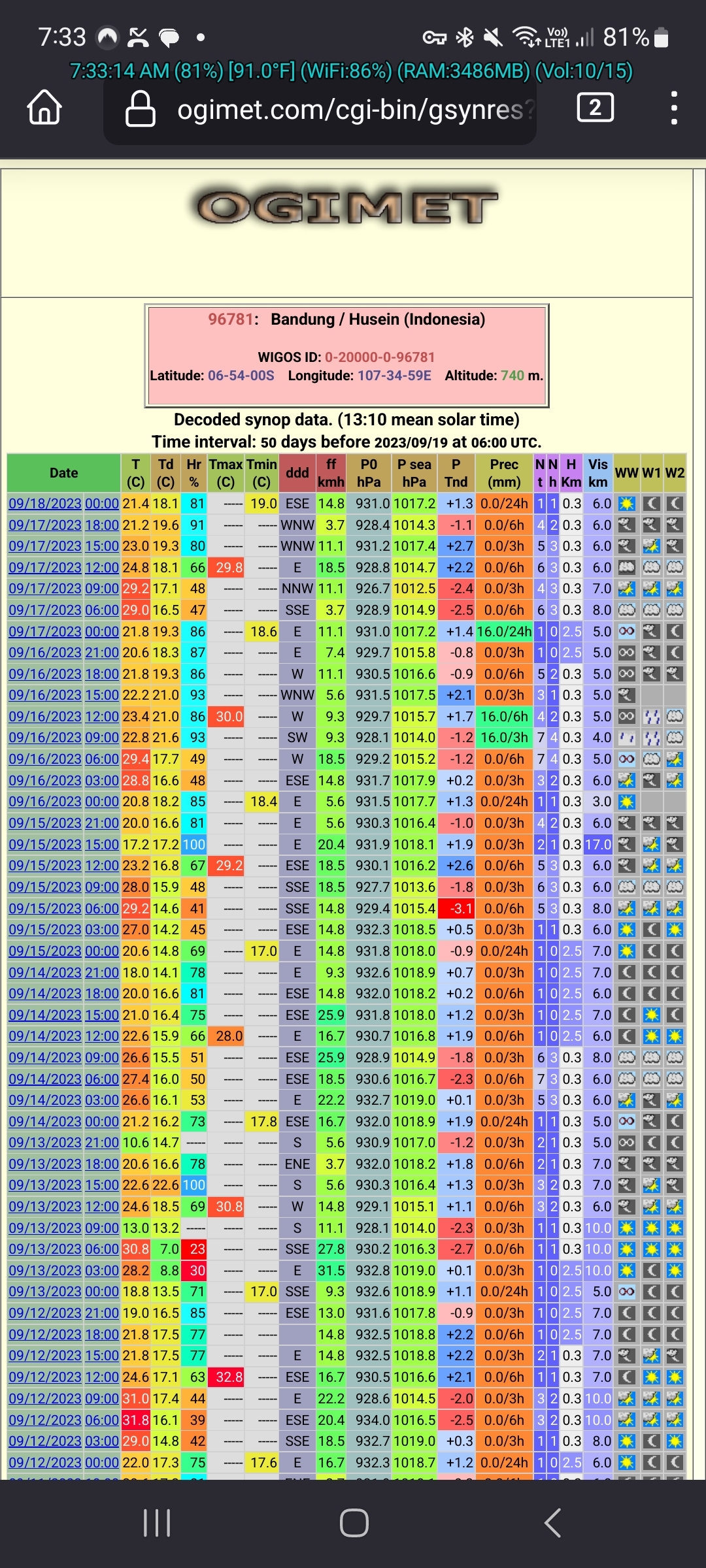 |
|