|
|
Post by Ethereal on Sept 17, 2023 22:27:17 GMT -5
Strong foehn effect at the footsteps of the Blue Mountains here in Sydney. 37C in the metro! Yikes!   |
|
|
|
Post by greysrigging on Sept 18, 2023 0:15:46 GMT -5
Winter and summer the same day in September !  |
|
|
|
Post by greysrigging on Sept 18, 2023 0:23:57 GMT -5
Exceptional ( but not quite record breaking ) Sept heat in the Sydney region. And some decent diurnals....   |
|
|
|
Post by greysrigging on Sept 18, 2023 1:32:35 GMT -5
|
|
|
|
Post by cawfeefan on Sept 18, 2023 3:31:50 GMT -5
While places to our north are baking, cloud cover kept a lid on temperatures in Melbourne today (maxed out at 18.0C). If it doesn't exceed 20C by 9am tomorrow, our 20C streak will be broken which means no record after all.
I can only imagine how ripped off Beerbloke would feel if he still lived here.
|
|
|
|
Post by greysrigging on Sept 18, 2023 4:31:10 GMT -5
Intense September Heat Toppling Records In SE Australia ( source: Weatherzone )  An unrivalled spell of early-season heat will continue to grip southeastern Australia over the next few days, with records likely to fall in several states. A broad and slow-moving low pressure trough is currently extending from Australia’s northwest to southeast, causing a large pool of hot air to spread over the continent. This hot air mass is affecting part of every mainland state and territory, sending temperatures more than 15ºC above average in some areas. If there was enough moisture in the atmosphere, this type of weather pattern might be producing a large rain-bearing northwest cloudband, like the type Australia saw frequently in 2022. But with a positive Indian Ocean Dipole developing to the northwest of Australia, the atmosphere is too dry for widespread rain and cloud over Australia. So, instead of channelling moisture across the country, the current weather pattern is driving unseasonable heat into southern and southeastern Australia.    Several places in SA registered their highest September temperature on record during the last couple of days. On Sunday, Ceduna reached 39.8ºC, which was its hottest September day since records began there in 1939. On Monday, Port Augusta had already reached 38.4ºC by 2:30pm local time, its highest September temperature in records dating back to 1957. Across the border in Vic, Mildura had reached 36.5ºC by 4pm local time on Monday, which is the state’s 5th highest September temperature on record. In NSW, Ulladulla (35.4ºC) and Montague Island (33.4ºC) both set new September records on Monday, while Bankstown (35.4ºC) had its warmest September day in 43 years. In addition to these daily September records, some of Australia’s largest cities are on track to break early-season records for the longevity of this hot spell. Monday is day three of five consecutive days over 29ºC in Sydney. This will beat the city’s previous September records of four days over 28ºC from 1928 and three consecutive days over 29ºC from 1946, with data available back to 1859. Canberra is also on track to register seven consecutive days over 23ºC, with Wednesday predicted be the final of this spell. This will beat Canberra’s previous September record of six days in 1965. Weatherzone will keep tracking the heat over the next few days and list major records on the Weather News page as they happen. |
|
|
|
Post by jgtheone on Sept 18, 2023 6:54:53 GMT -5
While places to our north are baking, cloud cover kept a lid on temperatures in Melbourne today (maxed out at 18.0C). If it doesn't exceed 20C by 9am tomorrow, our 20C streak will be broken which means no record after all. I can only imagine how ripped off Beerbloke would feel if he still lived here. It feels weird to complain about something like this tbh, given the run we had. |
|
|
|
Post by desiccatedi85 on Sept 18, 2023 8:29:46 GMT -5
greysrigging those Renmark diurnals are insane, 86°F/37°F and 95°F/41°F days.
|
|
|
|
Post by jgtheone on Sept 18, 2023 20:19:21 GMT -5
While places to our north are baking, cloud cover kept a lid on temperatures in Melbourne today (maxed out at 18.0C). If it doesn't exceed 20C by 9am tomorrow, our 20C streak will be broken which means no record after all. I can only imagine how ripped off Beerbloke would feel if he still lived here. It feels weird to complain about something like this tbh, given the run we had. Well, the early morning northerlies have kept the streak alive. 21.9C is the city's official max for Monday! |
|
|
|
Post by greysrigging on Sept 18, 2023 21:16:43 GMT -5
Sydney CBD at noon !  Sydney Sept records ( dating back to 1859 )  |
|
|
|
Post by greysrigging on Sept 18, 2023 21:34:18 GMT -5
Total Fire Ban For Sydney ( source: Weatherzone )  The NSW Rural Fire Service has declared a total fire ban for the Greater Sydney Region on Tuesday, September 19, as strong winds add an extra element of danger to the ongoing record-breaking September hot spell. It’s not known whether this is the earliest Sydney total fire ban that has ever been enforced, however it's safe to say it's extremely unusual for this time of year. Sydney is forecast to reach 34°C on both Tuesday and Wednesday In data dating back to 1859, the city has only reached 34°C in September on three occasions (once each in 2000, 1980 and 1965) This would be its first pair of 34°C days on record for September As of 9am, there are 61 fires burning around the state, with 13 not yet contained. Over 500 personnel are working to contain these fires. There is a TOBAN for the Greater Sydney Region and Far South Coast. But temperature is just part of the equation... It’s not just the remarkable early spring heat that has caused today’s fire ban in Sydney, even though Sydney has recorded top temps well above 30°C for at least three days now in virtually all suburbs, except a few coastal spots cooled by the sea breeze. Wind and rainfall deficiency are also factors at play here. Northwesterly winds will become gusty on both Tuesday afternoon and Wednesday. These are the scorching dry winds that typically fan east coast fires in summer.  You can see the big engines driving this system on the chart above. Hot air from the interior of Australia is being funnelled towards the NSW coast as it circulates around that large high pressure system centred in the Tasman Sea. Meanwhile the low pressure system lurking well south of the Great Australian Bight in the Southern Ocean is playing a part too, strengthening winds in southern Australia as the cooler air moves east. That's the wind side of things. As for rain, you can see on the graph below that Sydney has had a fraction of its average rainfall in four of the last five months.  There's a lot of bushland both in and around Sydney, and it is already very dry with smaller creeks reduced to a trickle. We should mention that the Sydney ban is one of two total fire bans in NSW this Tuesday, with the second being the Far South Coast region. Many more NSW regions are likely to see total fire bans on Wednesday as winds continue to strengthen ahead of a much-needed cool change in southern parts of the state. Meanwhile the Monaro Alpine Region has a high fire danger this Tuesday, even as Perisher remains open for skiing and snowboarding with several lifts running. We're not sure whether we've ever seen high fire danger during the ski season before. TOTAL FIRE BANS: WHAT ARE THE RULES? You can read more here at the NSW Rural Fire Service, including whether you can operate a gas BBQ outside and so on. But the key points are: A total fire ban means no fires out in the open. A total fire ban helps limit the potential of fires developing. During a total fire ban you cannot light, maintain or use a fire in the open, or to carry out any activity in the open that causes, or is likely to cause, a fire. General purpose hot works (such as welding, grinding or gas cutting or any activity that produces a spark or flame) are not to be done in the open. |
|
|
|
Post by Ethereal on Sept 19, 2023 1:14:27 GMT -5
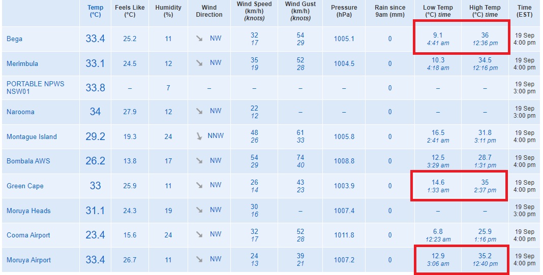
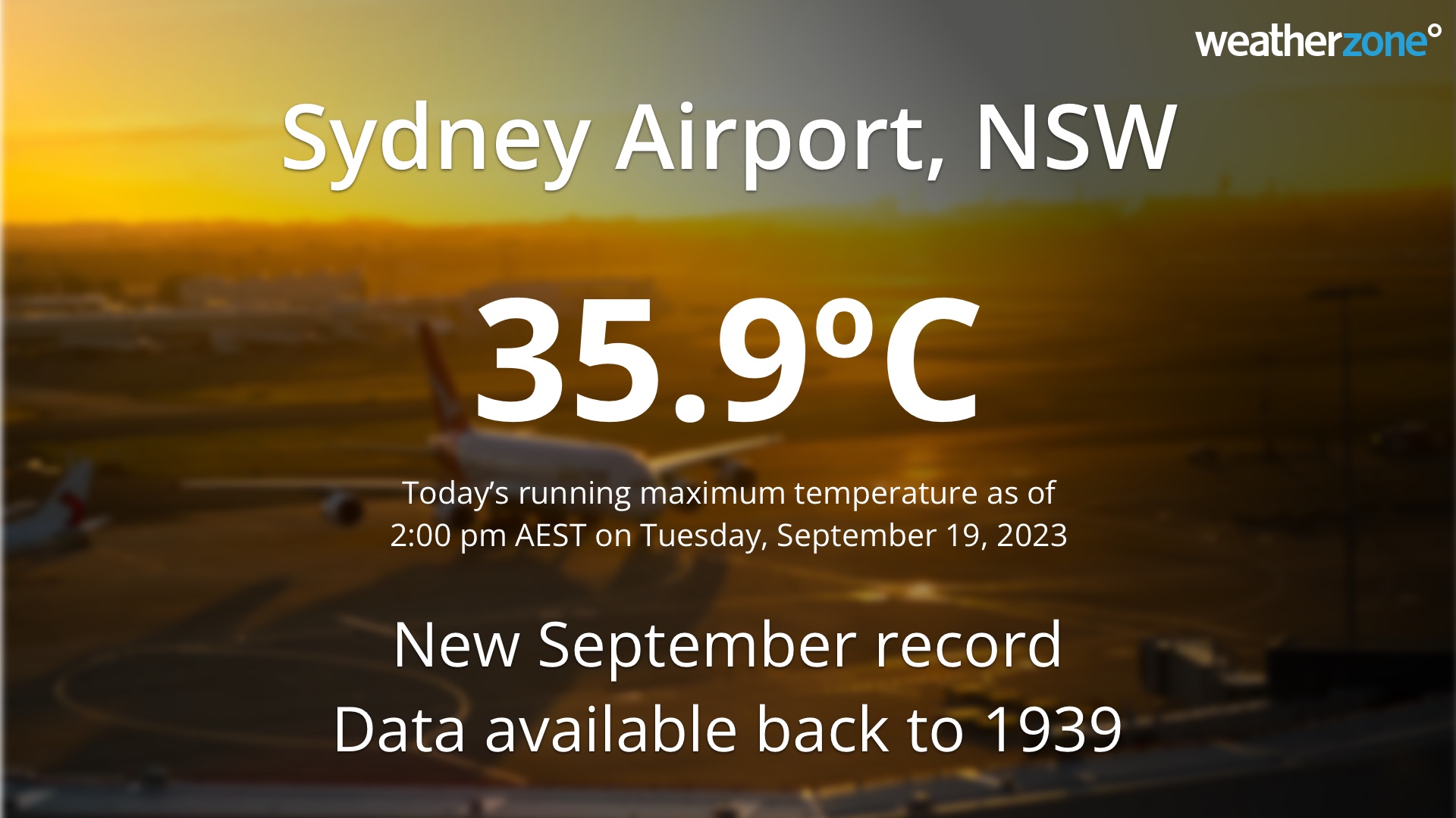
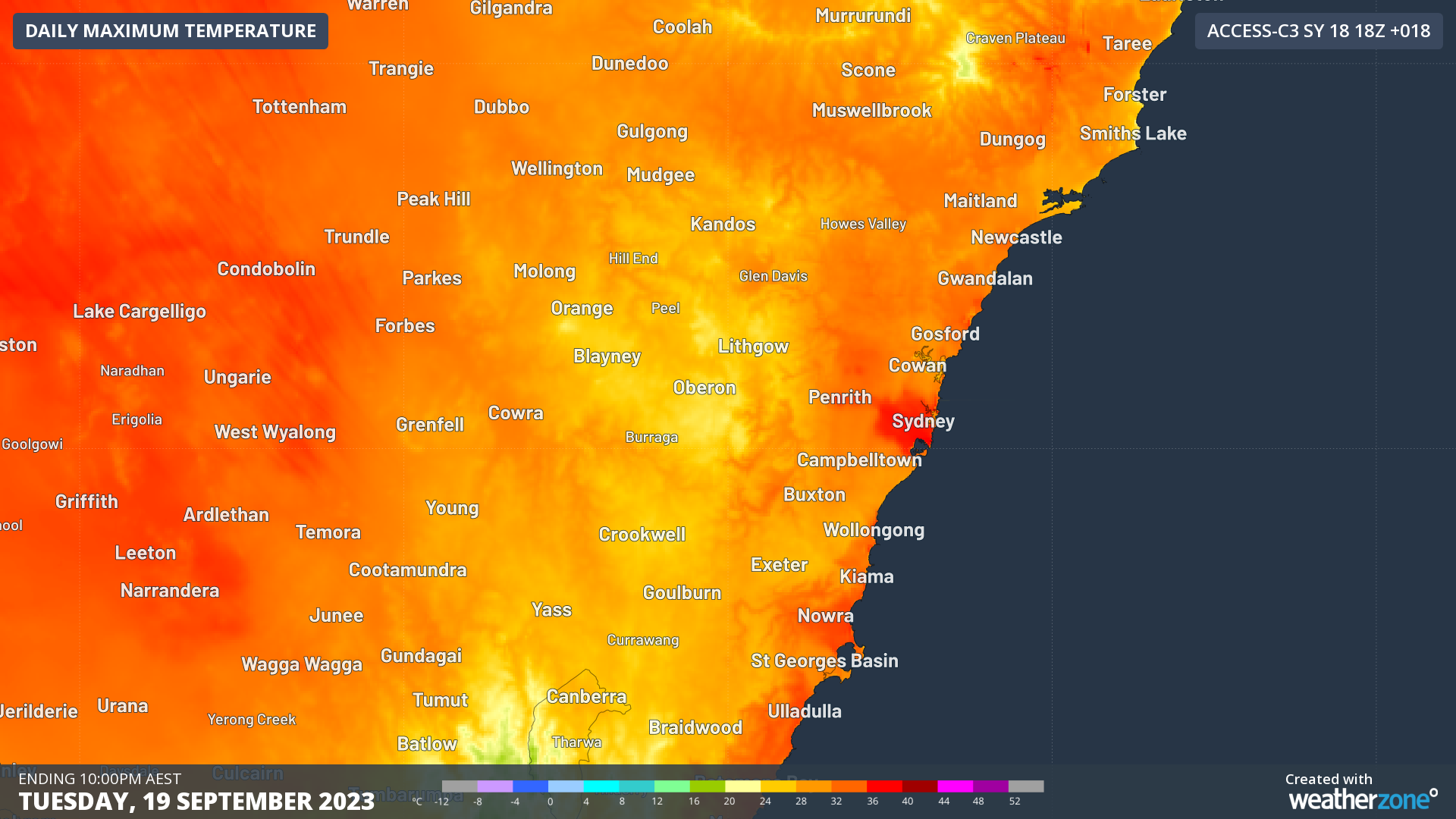
Seaward South Coast even hotter than most of Sydney today. And is Bega pulling a Penrith? The hottest temps have been recorded there so far. Foehn effect must be stronger there perhaps?  Forget Penrith, Sydney Airport recorded the hottest temps today!  Sydney Airport had reached as high as 35.7ºC by 2:00 pm, beating its previous September record of 35.6ºC from 2000, with data available back to 1939.  The city’s Observatory Hill weather station hadreached 34.6ºC, which was the city's equal highest September temperature on record, matching the same value from September 26, 1965. Data at Observatory Hill is available back to 1859.  www.weatherzone.com.au/news/sydney-registers-equal-hottest-september-day-on-record/1514971 www.weatherzone.com.au/news/sydney-registers-equal-hottest-september-day-on-record/1514971 |
|
|
|
Post by cawfeefan on Sept 19, 2023 3:19:39 GMT -5
East Gippsland temps today, probably due to the same Foehn effect  |
|
|
|
Post by kronan2 on Sept 19, 2023 9:56:52 GMT -5
First proper snowfall in Lapland this season. Kiruna a few minutes ago.  |
|
|
|
Post by greysrigging on Sept 19, 2023 23:48:03 GMT -5
So I've had a look at all the Sept +30c days at the Sydney Airport site... Here they are by the decade ( or there abouts ) 1939-1949 = 6 days 1950-1959 = 4 days 1960-1969 = 4 days 1970-1979 = 4 days 1980-1989 = 9 days 1990-1999 = 6 days 2000-2009 = 19 days 2010-2019 = 19 days 2020-2023 ( so far ) = 9 days ( and 5 consecutive days this month ( 2023 ) and the previous record from 2000 broken twice ( yesterday and today. ) And Syd Airport Sept means ( min and max ) showing a clear warming trend over 80 years of records 1939-1960 = 9.5c/19.9c 1961-1990 = 10.0c/20.4c 1991-2020 = 12.0c/21.7c     |
|
|
|
Post by AJ1013 on Sept 20, 2023 7:17:17 GMT -5
Summer ends in 24 days 🕰️
|
|
|
|
Post by kronan2 on Sept 20, 2023 10:02:09 GMT -5
Kiruna broke its September snow-depth record by a wide margin this morning.  Snow depth record for September in Kiruna Snow depth record for September in Kiruna
Updated September 20, 2023 Published September 20, 2023
The snow season has gotten off to a flying start in northern Norrland with snow depth records for the month of September in, among other places, Kiruna and Karesuando. The snowfall is linked to a deep low pressure over central Scandinavia. South of the low pressure, a lot of precipitation has also fallen, but in the form of rain.
The weather map for the night of Wednesday 20 September shows an extensive low pressure area over the North Atlantic and Northern Europe. The low pressure area has several sub-centres and a couple of these are over central Scandinavia. North of that, there has been abundant snowfall in several places and also in combination with a strong easterly wind.
September record in Kiruna and Karesuando, among others
The greatest snow depth during Wednesday morning was reported from Kiruna with 38 cm. It is by a good margin the greatest snow depth reported from Kiruna in September. The previous record was 21 cm on September 20, 1932. Snow depth measurements began in 1905.
The second largest snow depth of 25 cm was reported from Jukkasjärvi a few miles east of Kiruna. However, there is not such a long series of measurements.
Among stations with long or very long measurement series, Karesuando deserves to be mentioned, which has reported 15 cm of snow. Previous record was 7 cm on 28 September 1948. As for Kiruna, snow depth measurements began in 1905, but were more sporadic at first.
If we look at Sweden as a whole, 38 cm in Kiruna is the greatest snow depth in September in Sweden since 2003. Then Katterjåkk had 40 cm.
The Swedish September record is 62 cm in Sösjö in Jämtland on September 28, 1954. The last days of September 1954 are still unprecedented in terms of snow depth in September with just over half a meter at several stations in Dalarna, Hälsingland, Härjedalen and Jämtland.
www.smhi.se/bloggar/vaderleken-2-3336/snodjupsrekord-for-september-i-kiruna-1.200070 |
|
|
|
Post by Ariete on Sept 20, 2023 10:25:04 GMT -5
Stormy night and morning for most of Finland.
Helsinki:
Lapland:
|
|
|
|
Post by aabc123 on Sept 20, 2023 16:14:37 GMT -5
20/09 High 20.1c, low 13.4c, rather cloudy, some precipitation in the evening. 16.2c, cloudy at 00:00. The daily mean of the month so far has been about 2.7c warmer than the average, and there has been a little less precipitation than usual. The week is promising to be warm:  |
|
|
|
Post by greysrigging on Sept 21, 2023 16:14:29 GMT -5
|
|