|
|
Post by ral31 on Sept 17, 2018 20:01:12 GMT -5
Got pretty hot here today; high was 98F. Forecast to reach 97F tomorrow.
|
|
|
|
Post by firebird1988 on Sept 18, 2018 5:15:30 GMT -5
Currently 31.1°C at 3am Pacific (Normal Low 25.6°C); with a dewpoint of 11.7°C, the Heat Index is 30.6°C
Forecast High is 41.1°C (Normal High 37.8°C)
|
|
|
|
Post by Crunch41 on Sept 18, 2018 8:57:46 GMT -5
|
|
|
|
Post by nei on Sept 18, 2018 9:46:11 GMT -5
muggy morning; remnants of Florence passing through. Moisture feeding into a frontal boundary  bands coming in Turner's Falls, MA already recorded 3 inches |
|
|
|
Post by nei on Sept 18, 2018 9:50:35 GMT -5
tornado possible in eastern Massachusetts
|
|
Deleted
Deleted Member
Posts: 0
|
Post by Deleted on Sept 18, 2018 12:40:04 GMT -5
very high temperatures in southern sweden today. highest preliminary reading is 25.7C in gladhammar. swedish record for latest +25C day is from hudiksvall, 29th september, 2011.
|
|
|
|
Post by nei on Sept 18, 2018 13:22:45 GMT -5
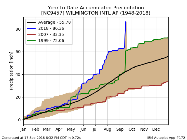
Wilmington, North Carolina got warm handsome rain. 1999 from Floyd was the previous record.  |
|
|
|
Post by nei on Sept 18, 2018 13:22:59 GMT -5
some flooding near Boston
|
|
|
|
Post by nei on Sept 18, 2018 15:00:34 GMT -5
Fall foliage season could be meh with all the warmth and humidity though New Hampshire weather patterns could be different than further south
|
|
|
|
Post by firebird1988 on Sept 18, 2018 19:09:27 GMT -5
Today's High was 40°C (Normal High 37.8°C)
|
|
|
|
Post by nei on Sept 18, 2018 22:17:40 GMT -5
microburst that was thought it could have been a tornado hit Saugus, Massachusetts
LOCATION...SAUGUS IN ESSEX COUNTY MA
DATE...SEPTEMBER 18 2018
ESTIMATED TIME...1107 AM EDT
ESTIMATED MAXIMUM WIND SPEED...70-75 MPH
MAXIMUM PATH WIDTH...250 YARDS
PATH LENGTH...1 MILE
BEGINNING LAT/LON...42.4613/-71.0088
ENDING LAT/LON...42.4581/-70.9901
* FATALITIES...0
* INJURIES...0
...SUMMARY...
A NATIONAL WEATHER SERVICE SURVEY TEAM LOOKED FIRST-HAND AT
DAMAGE THAT OCCURRED LATE THIS MORNING IN SAUGUS, MASSACHUSETTS.
THEY DETERMINED THAT A MICROBURST, OR STRAIGHT-LINE WINDS, WAS
THE CAUSE OF DOWNED TREES AND TREE LIMBS, A FEW OF WHICH FELL
AGAINST HOMES. THE DAMAGE WAS NOT THE RESULT OF A TORNADO.
ALTHOUGH TREES, TREE LIMBS, AND SOME WIRES WERE DOWNED ACROSS
MANY PARTS OF SAUGUS, THE MOST CONCENTRATED AREA STRETCHED
FROM THE WESTERN PART OF RIVERSIDE CEMETERY EASTWARD TO BETWEEN
STOCKER PLAYGROUND AND LINCOLN AVENUE. THIS IS APPROXIMATELY
A ONE-MILE LENGTH. THE MAXIMUM WIDTH OF THE MICROBURST WAS
AROUND 250 YARDS. THE ESTIMATED MAXIMUM WIND SPEED WAS
70 TO 75 MPH.
|
|
|
|
Post by firebird1988 on Sept 19, 2018 6:03:28 GMT -5
Currently 30.6°C at 4am Pacific (Normal Low 25.6°C); with a dewpoint of 20°C, the Heat Index is 32.8°C
Forecast High is 33.9°C (Normal High 37.8°C)
|
|
|
|
Post by P London on Sept 19, 2018 7:47:59 GMT -5
Very breezy today here in London though further north its VERY windy.
A woman supposedly died in Western Ireland as a caravan went off a cliff...
|
|
|
|
Post by AJ1013 on Sept 19, 2018 9:27:17 GMT -5
Torrential rain and thunderstorms forecast here tiday with a high of only 78F. Flooding will be a major concern this afternoon into tomorrow.  |
|
Deleted
Deleted Member
Posts: 0
|
Post by Deleted on Sept 19, 2018 10:52:51 GMT -5
 looks like the scandes will have its first widespread snowfall this season the coming days. |
|
|
|
Post by firebird1988 on Sept 19, 2018 19:07:44 GMT -5
Today's High was 33.9°C (Normal High 37.8°C)
|
|
|
|
Post by ral31 on Sept 19, 2018 19:58:14 GMT -5
Looks like the first taste of fall could be coming the end of next week. This is what the GFS is showing next Saturday morning.  The last time it was below 60F was May 7...   |
|
|
|
Post by firebird1988 on Sept 19, 2018 20:22:47 GMT -5
Still going to be warm here, that reading is for 5am our time and shows low to mid 80's Fahrenheit. Our normal low next Saturday is 23.3°C (74°F)
|
|
|
|
Post by nei on Sept 19, 2018 22:25:02 GMT -5
|
|
|
|
Post by Steelernation on Sept 19, 2018 22:41:18 GMT -5
Looks like some interesting weather the next few days with a high near 90 (!) on Friday then a rapid cold front coming through will bring highs in the low 60s on Saturday and possibly the first sub-50 (10 C) low since June.
Next week looks pretty average, maybe slightly above, but the incredible warmth of the first 2/3 of the month will be gone.
A top 10 finish should still happen though. Highs should finish 75-77 and the lows should finish 58-60.
|
|