|
|
Post by Crunch41 on Mar 10, 2019 19:04:14 GMT -5
Rainy yesterday, about 3/4 inch (19mm) with some wintry mix. It didn't melt much snow even though it was mild, wet, and windy. Northwest WI had a lot of snow, the northern half of the state will have snow until April at least. Another inch of rain this week in the forecast, some minor flooding is likely and the snow will probably melt. But, it might reach the mid 50s Thursday, the warmest since late October.
|
|
|
|
Post by Babu on Mar 11, 2019 7:53:10 GMT -5
Spring in Umeå  |
|
|
|
Post by Nidaros on Mar 11, 2019 11:46:55 GMT -5
With more sea ice than in recent years, Bear Island can again live up to it's name. Cred: twitter.com/Meteorologene Last time a polar bear was near the station was in 2013
|
|
|
|
Post by 🖕🏿Mörön🖕🏿 on Mar 11, 2019 13:16:11 GMT -5
Environment Canada has a snowfall warning up...
|
|
|
|
Post by AJ1013 on Mar 11, 2019 15:36:55 GMT -5
This probably belongs in the winter thread but whatever.  |
|
|
|
Post by Morningrise on Mar 12, 2019 18:37:01 GMT -5
It's finally happened! Saskatoon has gone up above freezing again for the first time since January 27th! We're currently standing at 2C as of 5:00pm today. It's normal to have pretty serious cold snaps in the winter here, but even in abnormally cold months we usually have a few days above freezing. I think this is the first time I've ever experienced a full month and a half without a single above-freezing temperature. It was a nice historic cold snap, but I'm glad it's over. Thankfully everyday in the forecast now is at or above freezing  And despite the lack of sun this evening, the snow is still melting rapidly. The streets are a muddy, slushy mess at the moment. Hopefully it goes rather quickly and we can go back to actually seeing real vegetation and dry ground soon enough. |
|
|
|
Post by Babu on Mar 13, 2019 12:37:24 GMT -5
Precipitation devation so far this spring. Incredibly wet in the SW.  And temperatures vs 1961-1990.  Umeå has averaged -2.4/-13.8 so far. The 91-18 average for 1-12th of March is 0.1/-8.7, so -3.8'C deviation. Quite different from SMHI's map... |
|
|
|
Post by Ariete on Mar 13, 2019 15:29:27 GMT -5
Ice days in February: 4
Ice days in March so far: 6
I need a safe space from winter. I'm such a snowflake.
|
|
|
|
Post by Wildcat on Mar 13, 2019 16:21:51 GMT -5
Tomorrow is looking good for some more thunderstorms. Temperatures should reach the low 70s again.  |
|
|
|
Post by Cadeau on Mar 13, 2019 16:55:11 GMT -5
Tomorrow is looking good for some more thunderstorms. Temperatures should reach the low 70s again.  The win-win situation in both of us will be that outlook map turns out to be shifting 150~200 km eastward where Lexington gets a higher chance to sit in the center of the yellow zone while my location barely bestride the external part. |
|
|
|
Post by Steelernation on Mar 13, 2019 17:12:15 GMT -5
Saw the first Canada geese of the season today and heard some bird song, it may be slow, but spring is coming.
Today hit 46 (8 C), the warmest of the month. Tomorrow should be neat 60.
Then after a brief cold snap, it looks like stable 40s. The end is in sight!
Oddly high diurnal and low dews for an overcast day today, guess my dream winters aren’t too unrealistic then.
|
|
|
|
Post by alex992 on Mar 13, 2019 17:24:18 GMT -5
Strong blizzard going on in the High Plains/Front Range today:  Look at those spots SW of Douglas, WY with potential 30-36" (76-91 cm) of snow and even a few isolated spots of 36-46" (91-117 cm)! And Limon, Colorado reported a 77 mph wind gust last hour! w1.weather.gov/data/obhistory/KLIC.html |
|
|
|
Post by Wildcat on Mar 14, 2019 14:09:07 GMT -5
Far western Kentucky
|
|
|
|
Post by Babu on Mar 15, 2019 5:10:57 GMT -5
Early and warm spring in Lund.
Since February the average has been 7.2/1.7, the last month has averaged 8.3/1.9 and March has averaged 7.7/1.5
The 91-17 average for March is 6.7/0.2. The 10 day forecast is also warmer than March has been so far. Leaves before the start of April seem very possible right now. If there's a heatwave in a couple of weeks, trees are guaranteed to start leafing.
|
|
Deleted
Deleted Member
Posts: 0
|
Post by Deleted on Mar 15, 2019 20:03:31 GMT -5
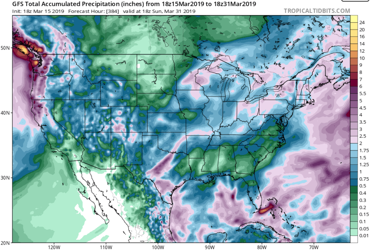
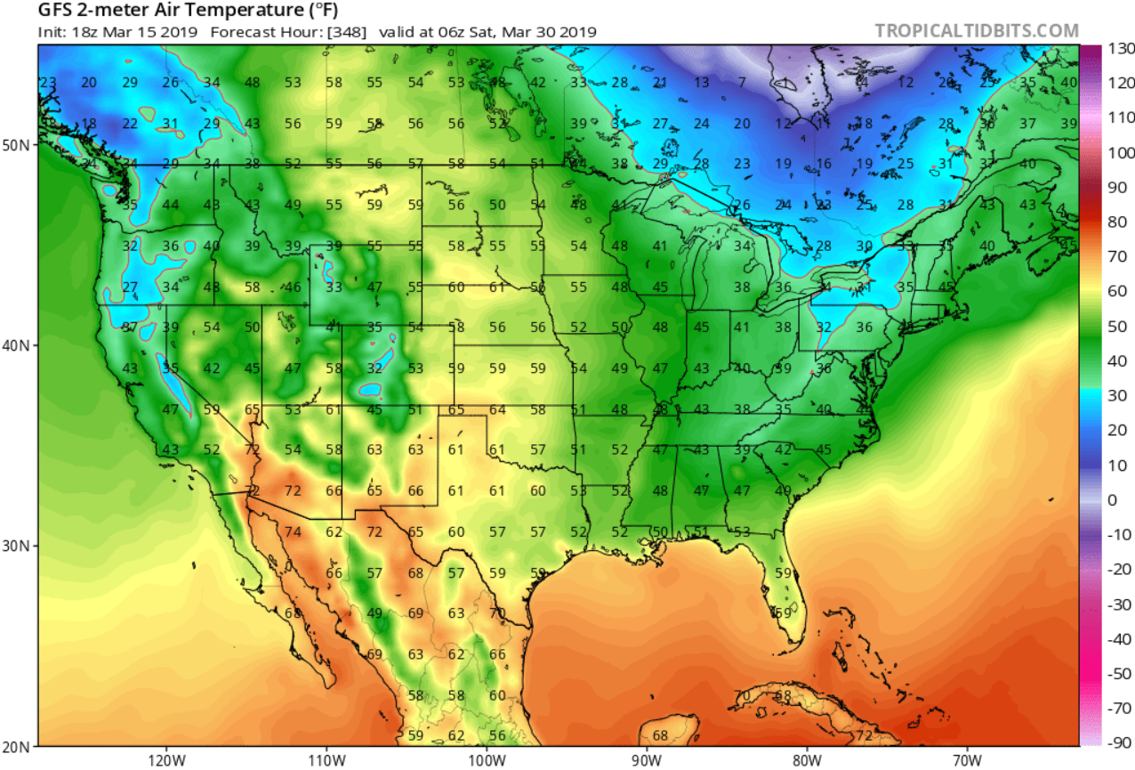
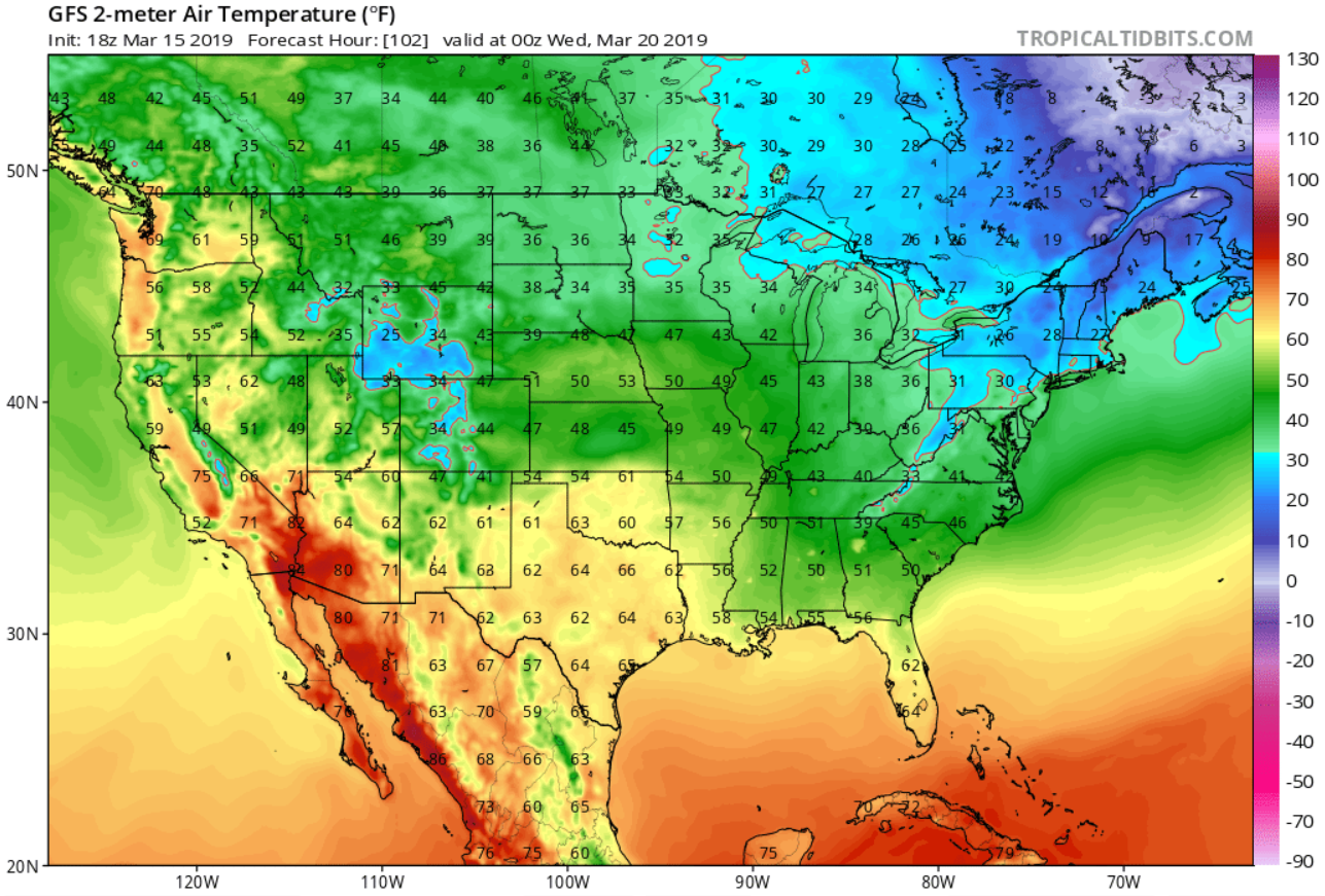
Precipitation for this month was almost certainly below average until the GFS model updated: 1.16" of precipitation so far plus about 2.5" shown in the GFS model adds up to about 3.66" for the month. Seattle's average precipitation for March is 3.72".  Also, GFS shows a cold snap at the end of March:  But it also shows some warmth on March 18-20.   |
|
Deleted
Deleted Member
Posts: 0
|
Post by Deleted on Mar 15, 2019 20:55:29 GMT -5
|
|
|
|
Post by Cadeau on Mar 15, 2019 23:13:26 GMT -5
Afternoon peak temps fell from 22.8°C on the 14th to 6.1°C on the 15th(≠ daily maximum), a wild contrast within a day of full blast spring mode then came back to the late winterish atmosphere. A strong southerly turned westerly which caused kept dropping constantly until early afternoon the next day around 3°C.
|
|
|
|
Post by Cadeau on Mar 15, 2019 23:26:07 GMT -5
Map of Cherry Blossom Forecast in Japan 2019 (Updated as of 14 March 2019) | City | Flowering Date | Full Blooming Date | | Tokyo | 21 March | 29 March | | Osaka | 25 March | 2 April | | Nagoya | 21 March | 30 March | | Fukuoka | 20 March | 31 March | | Sapporo | 29 April | 3 May | | Sendai | 3 April | 9 April | | Niigata | 7 April | 13 April |

|
|
|
|
Post by nei on Mar 16, 2019 12:07:59 GMT -5
I haven't heard about this either. Have you?
|
|
|
|
Post by nei on Mar 16, 2019 12:10:34 GMT -5
This probably belongs in the winter thread but whatever.  What's the coldest for the high plains? Feb 1936 ? |
|