|
|
Post by ral31 on Jan 5, 2020 22:23:50 GMT -5
Could be an active spell of severe weather coming.
|
|
|
|
Post by knot on Jan 6, 2020 0:19:52 GMT -5
New Record!Renmark, SA absolutely annihilates its previous coldest January maximum (19.3° C [Jan 1983]), with 15.6° C just yesterday; shattered by an astounding 3.7° C margin! 
|
|
|
|
Post by knot on Jan 6, 2020 1:29:53 GMT -5
|
|
|
|
Post by Speagles84 on Jan 6, 2020 7:44:12 GMT -5
|
|
|
|
Post by boombo on Jan 6, 2020 16:02:24 GMT -5
Any kind of cold record is extra impressive in this day and age but that is almost off the scale! Must feel genuinely polar as well given all the heat those places have had recently. |
|
|
|
Post by boombo on Jan 6, 2020 16:06:09 GMT -5
The start of this decade's weather at WFO Seattle: Jan 1: 12/6 °C, 14 mm Jan 2: 10/4 °C, 5 mm Jan 3: 15/8 °C, 3 mm Jan 4: 9/5 °C, trace Jan 5: 8/6 °C, 4 mm Average temperature: 8.3 °C (+3.3 °C) Precipitation: 26 mm (+3 mm) 15/8 °C is quite an anomaly for January. The January mean maximum for SeaTac is 13.6 °C and the record high is 19 °C. In addition, this morning had a low of 5 °C at UW and 3 °C at my location east of Seattle, at 3 am. At sunrise the temp rose to 7 °C at both locations, and it was very windy for Seattle. I like wind when it's not too cold though. I hope the whole decade is like this. But only for Seattle. Not for the whole world! Basically the same story here, solidly above average nearly every day for weeks and the forecast is still saying the January record (12.7C) might go tomorrow. www.weatheronline.co.uk/weather/maps/city?LANG=en&CEL=C&SI=mph&CONT=ukuk&LAND=UK®ION=0003&WMO=03339&LEVEL=52&R=0&NOREGION=1 |
|
|
|
Post by rozenn on Jan 6, 2020 16:50:26 GMT -5
Happening times in Aussie. This polar outbreak must be welcomed, and it's so ridiculously chilly that I think I'd even embrace it. Meanwhile here the catastrophic winter of 2019-20 goes on. It's really a disgrace, I think we've seen all the worst synoptics recently, between December's potent and wet zonal flow, to the New Year western Euro high to this month's mellow and anticyclonic zonal flow. It's a pain to follow really, I think I need a break from the models. Look at this steaming pile of horseshit. Any map, from any model, any run, is painfully ugly to look at.       What a legendary summer this would have been, had the same synoptics occured at the right time of the year. |
|
|
|
Post by Ariete on Jan 7, 2020 11:56:11 GMT -5
The all-time January heat record in Turku (8.5C) might be in danger tomorrow. FMI forecasts 8C highs. Average high this week is 0.3C. Åland might see temps up to 10C, but the all-time record of 10.9C should be safe.
This setup is possible due to the general synopsis rozenn posted. Föhn-reinforced strong westerly winds, no snow and ice -> very high temperatures. |
|
|
|
Post by Nidaros on Jan 7, 2020 17:30:17 GMT -5
Seems it was up to 12.4C at Holmen around 10:00 AM today in far northern Norway, Troms province, east of Tromsø. Extreme winter temp at 70N.
That place is at the head of a fjord with steep mountains surrounding the small town, so again a typical foehn-location (also known by its sami name, Birtavarre). Data: last 24 hrs at Holmen, Birtavarre
|
|
|
|
Post by AJ1013 on Jan 7, 2020 18:12:42 GMT -5
This is what I want to see! Fantasy range obviously but nice to have models trending in this direction   |
|
|
|
Post by nei on Jan 7, 2020 23:54:25 GMT -5
Happening times in Aussie. This polar outbreak must be welcomed, and it's so ridiculously chilly that I think I'd even embrace it. Meanwhile here the catastrophic winter of 2019-20 goes on. It's really a disgrace, I think we've seen all the worst synoptics recently, between December's potent and wet zonal flow, to the New Year western Euro high to this month's mellow and anticyclonic zonal flow. It's a pain to follow really, I think I need a break from the models. Look at this steaming pile of horseshit. Any map, from any model, any run, is painfully ugly to look at.    What a legendary summer this would have been, had the same synoptics occured at the right time of the year. also very bland winter in the eastern US. That's one of the cleanly circular patterns I've seen; polar vortex trapped in the high arctic, no cold spilling out, just an uneventful zonal flow here |
|
|
|
Post by nei on Jan 7, 2020 23:58:20 GMT -5
short lived cold snap coming before weekend warmth. strong wind but bad timing means no colder than 30°F in NYC Yahya Sinwar Northampton, 18°F is slightly above the daily min there but that's chilly for a night that's not calm and no radiational cooling. high of only 25°F there  |
|
|
|
Post by nei on Jan 8, 2020 0:03:28 GMT -5
|
|
|
|
Post by 🖕🏿Mörön🖕🏿 on Jan 8, 2020 1:49:01 GMT -5
Yeah I know (like his Saharan snowfall one I scolded him on). But it is an interesting find. Nothing to do with AGW or lack thereof.  |
|
|
|
Post by Ariete on Jan 8, 2020 11:57:14 GMT -5
The weather here was an absolute fizzer. High was 7.7C, not even close to record. Neither did any station record 10C.
|
|
|
|
Post by Nidaros on Jan 8, 2020 12:09:09 GMT -5
12.4’C now confirmed as new January all-time high in Norway’s northenmost province (Troms og Finnmark). Old record 12.1’C
|
|
|
|
Post by rozenn on Jan 8, 2020 14:35:00 GMT -5
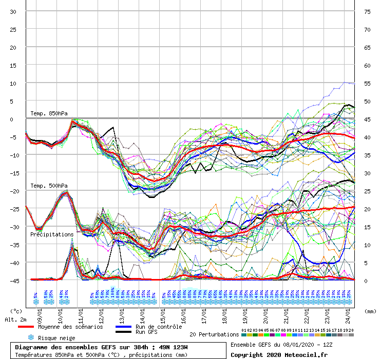
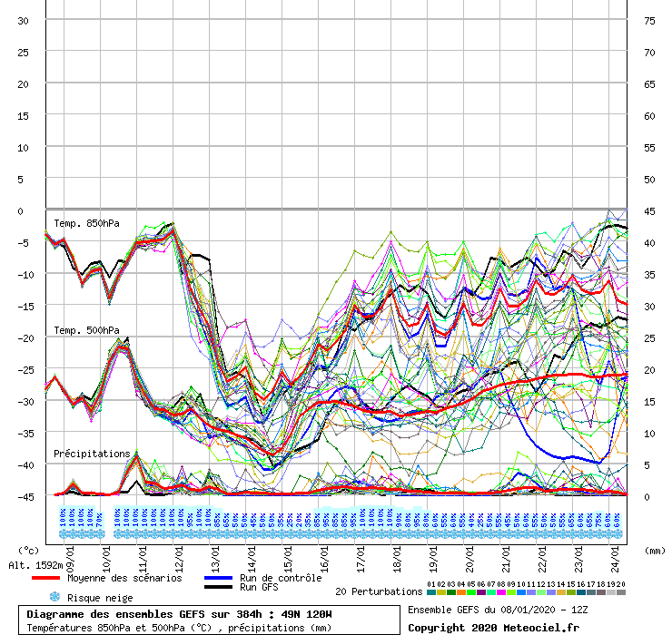
Funky map. 6 am temps, basically today's lows. Subpolar Spain and subtropical Channel jajajaja  You gotta love it when the warmest perturbation of the GFS ensemble shows 850 mb temps in the -10s (diagram for Vancouver here). The operational GFS is the coldest, but I'd trade places with Candle no matter what:  No perturbation above -20°C for the Okanagan and a GFS op @ -33°C  What are the record cold 850 mb temps in the PNW/BC 🖕🏿Mörön🖕🏿 omegaraptor @qidb602? The GFS shows 500 mbar heights below 512 dam combined with sea level pressures around 1040 mbar. That's positively arctic!  The Euro is slightly less cold but still wintry enough. The largest anomalies would be slightly further east it seems. For Vancouver:  And the Okanagan:  |
|
|
|
Post by Wildcat on Jan 8, 2020 14:44:35 GMT -5
Wow, highs in 80F and above up to NC yesterday. It hasn't hit 80F in January in Alexandria since 2008. Hoping it doesn't happen this year...  Insane gradient in NC |
|
|
|
Post by aabc123 on Jan 8, 2020 16:28:00 GMT -5
Ongoing temperature anomaly everywhere in northern and eastern Europe and Siberia for the next 10 days (well, only Chukotka is below average).  |
|
|
|
Post by nei on Jan 8, 2020 18:42:51 GMT -5
second snow squall came in around 3 pm in Manhattan. heavier rates, stronger winds. felt cold. the blue sky with big puffy clouds. clear after sunset, cold night after the snow squall passed boston |
|