|
|
Post by rozenn on Jan 21, 2020 18:08:21 GMT -5
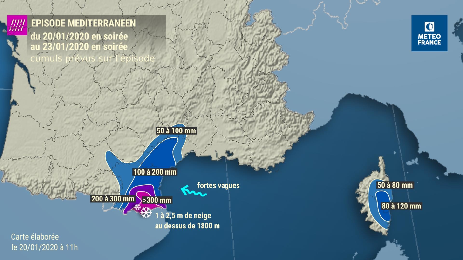
Gotta love it when the forecast says "2.5 m of snow expected".   |
|
|
|
Post by 🖕🏿Mörön🖕🏿 on Jan 22, 2020 0:27:39 GMT -5
Still can't believe what a potent storm this was for St. John's and the vicinity.
|
|
|
|
Post by Donar on Jan 22, 2020 3:53:31 GMT -5
Overnight low was -6.6 °C, the coldest temperature this winter so far.
|
|
|
|
Post by Donar on Jan 22, 2020 3:58:36 GMT -5
Here are min temps for southern Germany, nice inversion there: that 5°C is from the highest mountain (1490 m)
|
|
|
|
Post by Ariete on Jan 22, 2020 9:26:59 GMT -5
Jajajajaja 105 cm snow depffffffffff in Kilpisjärvi, 0 cm in Kronoby.
The last time Turdku went below freezing was 13 January. #subtropique_lyfe #AGW #notmadedfrost
|
|
|
|
Post by shalop on Jan 22, 2020 12:15:35 GMT -5
|
|
|
|
Post by 🖕🏿Mörön🖕🏿 on Jan 22, 2020 12:47:20 GMT -5
Taloyoak is probably more realistic. -42C there with a -55C wind chill. |
|
|
|
Post by rozenn on Jan 22, 2020 13:10:48 GMT -5
Here are min temps for southern Germany, nice inversion there: that 5°C is from the highest mountain (1490 m)
And I bet the -12°C reading is from Sonnenbühl or some other frost hollow in the Swabian Alb? Nice and wintry here too, today's extremes were 4.4/-2.6°C. It feels like a 0/-8°C day given how mild it has been this winter. |
|
|
|
Post by rozenn on Jan 22, 2020 17:01:09 GMT -5
Interesting phenomenon in the afternoon, central Paris went from 3.9°C 2 pm to 1.9°C at 3 pm, together with stronger winds.
Apparently this happens when the UHI creates a localized area of unstable air when it's cold enough aloft. The bubble of hot air over the city rises and the local airmass becomes more and more unstable, until the hot air bubble litterally rises above the ground and gets replaced by cooler air at ground level.
Indeed on the windward side CDG didn't get above 1.6°C. 0.3°C with 77 km/h gusts there during the phenomenon.
|
|
|
|
Post by rozenn on Jan 22, 2020 17:06:12 GMT -5
Gotta love it when the forecast says "2.5 m of snow expected".   Locally already above 300 mm in places. Montferrer leads the count with 337 mm at 4 pm. It's still getting hammered so prolly in the 400s or close now. No news from the mountains since the morning. Looks intense there. |
|
|
|
Post by rozenn on Jan 22, 2020 17:09:00 GMT -5
Tweet says "room with a view", from this morning. They were most lilely in for another 24 hours of intense snowfall. Dunno.
|
|
|
|
Post by Donar on Jan 22, 2020 17:14:02 GMT -5
Exactly, it's from Sonnenbühl, it even went down to -13.7 °C later today. |
|
|
|
Post by rozenn on Jan 22, 2020 17:47:22 GMT -5
I paid a visit to that weather station given the interesting local climate. It has handwritten temp records on site, awesome stuff.  It's time to revive this awesome thread btw. |
|
|
|
Post by trolik on Jan 22, 2020 21:23:27 GMT -5
Tweet says "room with a view", from this morning. They were most lilely in for another 24 hours of intense snowfall. Dunno. now thats the definition of snowed in |
|
|
|
Post by trolik on Jan 22, 2020 21:24:18 GMT -5
Still can't believe what a potent storm this was for St. John's and the vicinity. i saw they got 30 inches of snow for one single storm, idk if its a record or not tho |
|
|
|
Post by ral31 on Jan 22, 2020 22:17:33 GMT -5
Some reports of light sleet in the area today, though I didn't see anything.
Temp didn't get above 41F today with light rain starting late morning. Looks like today will be the only day this month with a max in the 40's. Warming up a bit this evening with southeasterly flow. Up to 44F now. Forecast to get above 60F tomorrow.
Lows the past couple of days have been disappointing with temps ending up warmer than forecast. Only one night actually got below freezing. Lows were 34F, 30F, 33F the past 3 nights.
|
|
|
|
Post by srfoskey on Jan 23, 2020 0:40:57 GMT -5
It supposedly snowed last night for a little bit, but I was already asleep and it didn't accumulate.
|
|
|
|
Post by Babu on Jan 23, 2020 5:26:05 GMT -5
Winter so far in Kronoby compared to Weatherspark's approximate 1980-2016 average: So December there was very mild  But nowhere near as mild as January has been, where almost all lows have been above the 10% mark.  Same hasn't quite been true for Umeå even though it's been great here too.   |
|
|
|
Post by Speagles84 on Jan 23, 2020 5:52:37 GMT -5
15F right now, (1F below average), high is forecasted to be 40F today (6F above average) so back to above average it seems  |
|
|
|
Post by Steelernation on Jan 23, 2020 19:58:04 GMT -5
40/18 (4/-8 c) and completely overcast today. No front either. Maybe my dream winters aren’t so unrealistic then AJ1013. |
|