|
|
Post by Giorbanguly on Jul 6, 2020 2:16:24 GMT -5
Surprisingly dry the past week. Seems like monsoons will be coming back with a vengeance next week however
|
|
|
|
Post by chesternz on Jul 6, 2020 4:30:33 GMT -5
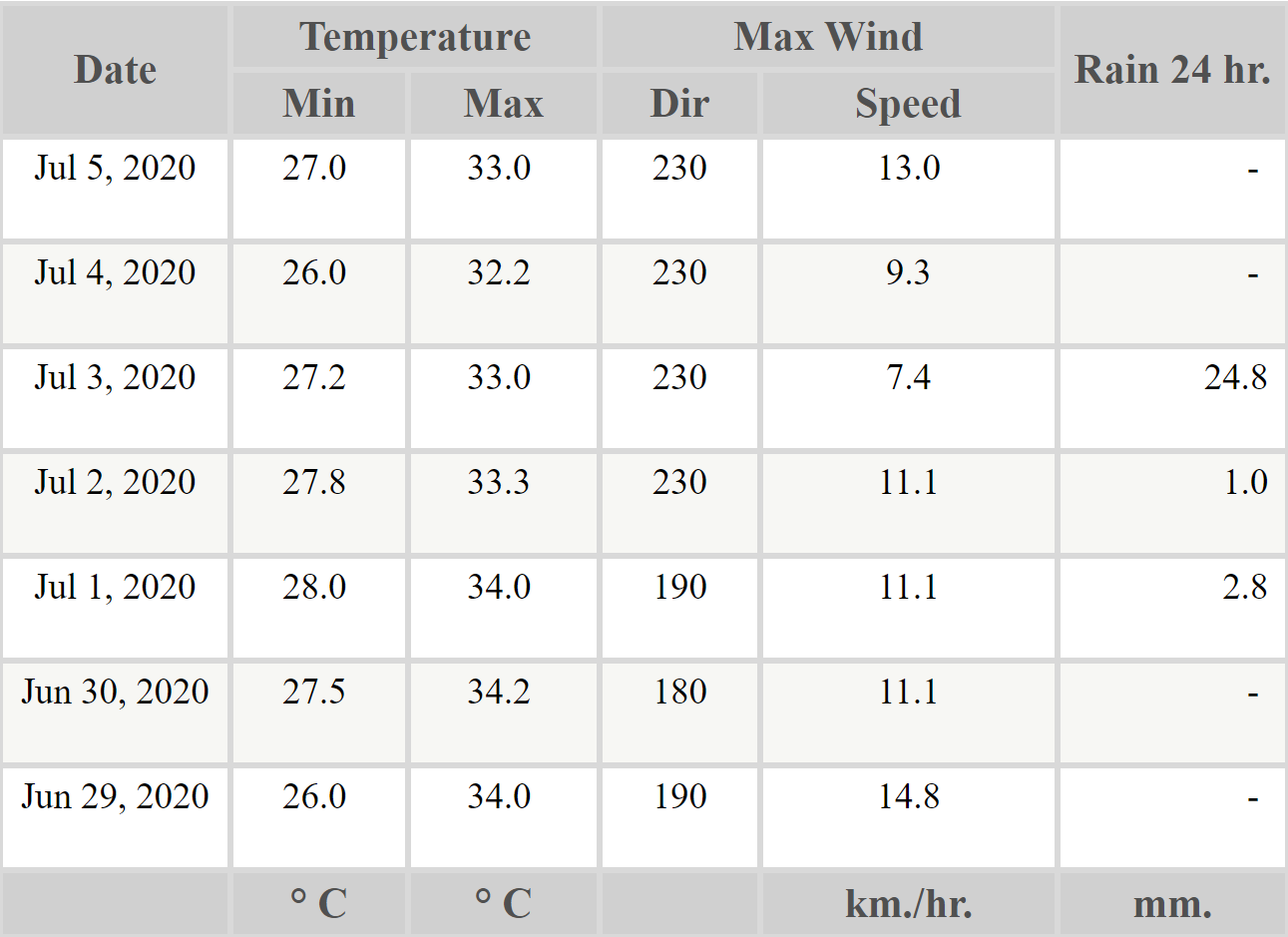
Only one significant rain day last week and no thunderstorms:  |
|
|
|
Post by Speagles84 on Jul 6, 2020 14:54:54 GMT -5
Heat wave now record breaking. Ties the daily record as well as my PWS record. 92F degrees!!!!!!!
|
|
|
|
Post by Yahya Sinwar on Jul 6, 2020 15:05:05 GMT -5
Heat wave now record breaking. Ties the daily record as well as my PWS record. 92F degrees!!!!!!! Isn't all that impressive, with all due respect where you live is capable of much much hotter weather. Hitting a daily record is great but as angler says isn't all that!
You are sounding a bit like aj.
|
|
|
|
Post by Speagles84 on Jul 6, 2020 15:08:04 GMT -5
Heat wave now record breaking. Ties the daily record as well as my PWS record. 92F degrees!!!!!!! Isn't all that impressive, with all due respect where you live is capable of much much hotter weather. Hitting a daily record is great but as angler says isn't all that!
You are sounding a bit like aj.
Since I've lived here I've hit 90F five times, over 4 years. Two of those days have been today and yesterday. So yes, it's quite hot for me. |
|
|
|
Post by Steelernation on Jul 6, 2020 21:32:20 GMT -5
High was 90 (32 c) for the 2nd straight day today.
Other places were much more impressive though with 95 in Dansville, 93 in Syracuse and even 94 in Buffalo, which has now had 4 straight 90s.
We have a heat advisory in effect from Tomorrow until Friday with temps in the low to mid 90s.
|
|
|
|
Post by jgtheone on Jul 7, 2020 9:09:47 GMT -5
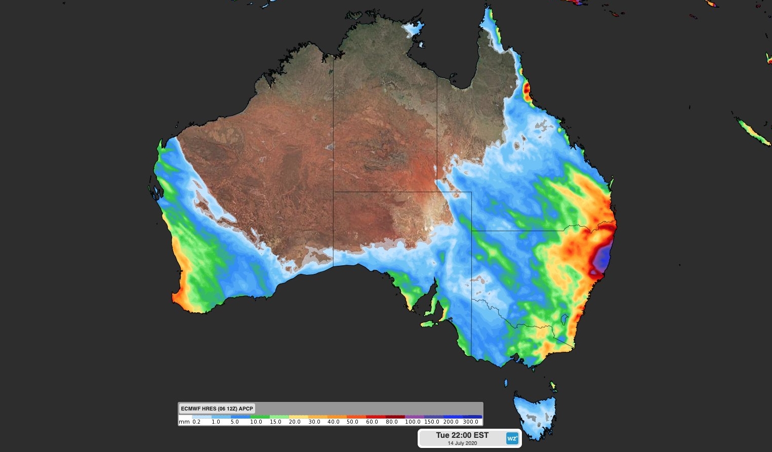
Rain perfectly seems to avoid the ACT, lol. Crazy falls around northern NSW though  |
|
|
|
Post by Steelernation on Jul 7, 2020 19:13:14 GMT -5
High was 93 (34 c) today. It matched the forecast but was nowhere near the 98 f that had been forecast for today on Friday.
Dews were in the low 60s so another dry day. It’s been a pretty dry summer with only 2 days having 70 f dews so far and almost all the hot days have been dry.
It’s still 91 f as of 8 PM, so there’s been 6 hours over 90 today which is a lot for here.
Today was the 3rd straight 90+ day which qualifies as a heat wave. This is the first heat wave since July 13-16th, 2018. And today is the 6th 90+ of the year, which already matches last crummer’s total.
|
|
|
|
Post by Beercules on Jul 8, 2020 5:42:32 GMT -5
out in outback SA dropped to -5.1C this morning. Only 2.1C here due to the overcast.
|
|
|
|
Post by Steelernation on Jul 8, 2020 19:13:52 GMT -5
Today was a forecast bust but still managed to hit 90 (32 c) for the 4th straight day. Today was more humid with dews in the upper 60s.
The morning low was only 71 (22 c), so today should have the first 70 f low of the year.
Consecutive days streaks—records in parentheses:
90 f: 4 (9 in 1973)
85 f: 7 (14 in 1964)
80 f: 8 (35 in 2016)
75 f: 23 (78 in 2016)
30 c: 4 (12 in 1964)
25 c: 14 (59 in 2016)
There is no sign of anything below the low 80s in the forecast but the weekend “cooldown” will end any chance of setting the record for the hotter temp streaks. Some could still be top 10 though.
|
|
|
|
Post by Morningrise on Jul 8, 2020 22:50:31 GMT -5
Impressive heat in Southern Ontario and Quebec lately, this could be an all-time record setting month for many weather stations.
Toronto currently has an average high/low of 33C/21C for the first week of July, with only a brief break from the heat for a few days before it's expected to resume with highs above 30C for most of the next two weeks.
Point Pelee, at the very southern tip of Ontario/Canada, recorded an air temperature of 33C with a dew point of 25C at 7:00pm local time today.
|
|
|
|
Post by jgtheone on Jul 8, 2020 23:29:43 GMT -5
Can't believe I forgot this one: Mildura had a high temp of 7.6C yesterday due to lingering fog. Swan Hill reached 7.4C and Hopetoun only 6.1C!!
|
|
|
|
Post by srfoskey on Jul 9, 2020 0:55:40 GMT -5
ChicagoGeorge keeps talking about how hot and dry the next few weeks will be, but the GFS is looking pretty wet for a lot of the Midwest. And the heat looks somewhat above normal, but not too impressive, given how much the GFS tends to overestimate things.
|
|
|
|
Post by Beercules on Jul 9, 2020 1:19:26 GMT -5
Can't believe I forgot this one: Mildura had a high temp of 7.6C yesterday due to lingering fog. Swan Hill reached 7.4C and Hopetoun only 6.1C!! Are you kidding me  My high was 13.5C. Well that's an all-time record low for Mildura Airport. Oh yeah, and when anywhere in Canada starts getting 25C dewpoints, it's time for me to jump off a bridge. |
|
|
|
Post by Giorbanguly on Jul 9, 2020 1:42:26 GMT -5
Rochester actually looks hotter next week than NYC. Wtf
|
|
|
|
Post by Steelernation on Jul 9, 2020 11:47:49 GMT -5
Rochester actually looks hotter next week than NYC. Wtf The core of the heat is in the Midwest this time so Rochester is getting hotter since it’s farther west. We have finally entered the “abnormally dry” category for the latest drought monitor update. |
|
|
|
Post by boombo on Jul 9, 2020 13:29:54 GMT -5
We've just had two weeks of the absolute worst midsummer weather I have EVER seen, we probably haven't even broken 30 sun hours this whole time   I knew we'd have to pay for that record sunny April and May at some point but I wasn't expecting this bad, my brain thinks it's October already. |
|
|
|
Post by rozenn on Jul 9, 2020 13:43:05 GMT -5
We've just had two weeks of the absolute worst midsummer weather I have EVER seen, we probably haven't even broken 30 sun hours this whole time   I knew we'd have to pay for that record sunny April and May at some point but I wasn't expecting this bad, my brain thinks it's October already. This zonal flow we currently have seems more typical of winter. We're in the anticyclonic part south of the barocline zone though, so it's actually hot today (32°C). |
|
|
|
Post by boombo on Jul 9, 2020 13:47:17 GMT -5
We've just had two weeks of the absolute worst midsummer weather I have EVER seen, we probably haven't even broken 30 sun hours this whole time   I knew we'd have to pay for that record sunny April and May at some point but I wasn't expecting this bad, my brain thinks it's October already. This zonal flow we currently have seems more typical of winter. We're in the anticyclonic part south of the barocline zone though, so it's actually hot today (32°C). We're not really capable of consistent 5C below average maxes and heavy precipitation here in winter though, because that would actually mean decent snow. |
|
|
|
Post by Steelernation on Jul 9, 2020 19:04:02 GMT -5
Today was awesome...we actually went overshot the forecast and hit 97 (36.1 c)!
This is the hottest temp since 2012 and is tied for the 2nd hottest temp since 1988. It was also the 5th straight 90+ day.
During the hottest part of the day, dews were in the high 50s although it was more humid in the morning and now in the evening.
I did about 2 hours of yardwork today—couldn’t waste the hottest day in years being inside.
|
|