|
|
Post by Steelernation on Jul 15, 2020 22:16:03 GMT -5
Through 15 days, July has averaged 87.8/65.3 with 7 days hitting 90.
The next week looks warm with another brief heatwave with temps in the 90s over the weekend. Then it’s just up to the last week not to ruin the month.
|
|
|
|
Post by Morningrise on Jul 15, 2020 22:51:47 GMT -5
Palermo, Italy, which has a Mediterranean climate and averages around 5 or 6 mm of rain in July (depending on the station), just had a storm roll through that apparently dropped over 100mm of rain, causing catastrophic flooding and two deaths.
|
|
|
|
Post by knot on Jul 16, 2020 3:05:54 GMT -5
Kunuma Angus Stud (1,317 m) reported a daily snowfall total of 25 cm on the 13th:   |
|
|
|
Post by kronan on Jul 16, 2020 7:05:51 GMT -5
So today Göteborg managed to hit 20°C for the first time this month.  This 1st half of July has been the coldest in my lifetime. Shockingly bad. |
|
|
|
Post by rozenn on Jul 16, 2020 13:25:46 GMT -5
Somehow this absolute borefest of a July managed to produce what looks like a tornado yesterday near Nangis (SE of Paris):  |
|
|
|
Post by Wildcat on Jul 16, 2020 19:54:28 GMT -5
Extreme humidity today. Highest dewpoint since 2011. Too bad we couldn’t quite get to 80F.  |
|
|
|
Post by 🖕🏿Mörön🖕🏿 on Jul 16, 2020 22:19:58 GMT -5
So today Göteborg managed to hit 20°C for the first time this month.  This 1st half of July has been the coldest in my lifetime. Shockingly bad. Welcome to the forum. That is insanely bad. Similar shittiness here as up until yesterday the max was 21°C for the month.  |
|
|
|
Post by 🖕🏿Mörön🖕🏿 on Jul 16, 2020 23:10:40 GMT -5
July so far here, halfway through the month. Laughably similar to June, and May for that matter. I still say April was the most pleasant month this year.  |
|
|
|
Post by Steelernation on Jul 16, 2020 23:32:19 GMT -5
Today was another washout with a total of 1.70” (43 mm). It rained pretty much nonstop after 1 PM although it was broken by a nice thunderstorm in the afternoon.
July now has 5.06” (129 mm), the 3rd wettest July 1-16 ever. However, this has fallen on just 3 days.
|
|
|
|
Post by Babu on Jul 16, 2020 23:35:30 GMT -5
June and July compared at Umeå Airport. Basically June was an average July, and July has been an average June so far.  Meråker inland of Trondheim. Their May and July (so far) are the coldest, and their June is the warmest in the last 16-17 years that the station has been online.  (Showing highs compared to record coolest and warmest) And here's Östersund at Trondheim's latitude but on the Swedish side of the border and 400m asl  |
|
|
|
Post by ral31 on Jul 17, 2020 15:29:47 GMT -5
T-storm came yesterday though I didn't get that much rain from it - 0.17". Before yesterday, I had gone just over a week without any precip. The next few days look dry but hopefully it turns wetter next week...
Highs in the mid 90's the past couple of days and coming up. It got up to 98F on Monday.
|
|
|
|
Post by bizzy on Jul 17, 2020 17:02:33 GMT -5
Mostly 70’s and mist/clouds today, but the high dews have arrived, it’s currently 80/75 and partly cloudy, a late high for the day.
The next several days are going to be far warmer (90’s) and the steaminess looks to persist even after the real heat leaves.
|
|
|
|
Post by nei on Jul 18, 2020 6:45:14 GMT -5
thick fog this morning after; humid air after heavy rain yesterday cool and condensed  most of last week has been cool and often cloudy; mild nights only once going below 60 and not by much but barely breaking 80°F. Really pleasant inside and out, never felt cool or hot |
|
|
|
Post by nei on Jul 18, 2020 7:02:02 GMT -5
had 1.5" of rain in the last few days; grass looks bright green. Less sun + rain cooled the Connecticut River but still warmer than usual at 78°F. With a few very hot days coming wonder if the river can break 82°F again. 84°F?! Reaching acceptable temperatures for AJ1013 |
|
|
|
Post by Steelernation on Jul 18, 2020 19:07:57 GMT -5
Today was another bust, high was only 88 (31 c).
Forecast highs last 3 days: 86, 87, 91
Actual highs last 3 days: 81, 85, 88
Thursday at least had storms come through earlier than expected, today and yesterday though were perfectly sunny and dry.
Tomorrow has a forecast high of 95 (35 c) but ten bucks says it doesn’t get past 92.
|
|
|
|
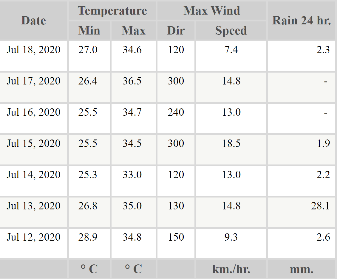
Post by chesternz on Jul 19, 2020 1:50:26 GMT -5
A mostly sunny week with a little bit of rain - mostly very brief showers but one proper rainfall on the 13th:  |
|
|
|
Post by Benfxmth on Jul 19, 2020 7:06:04 GMT -5
This past week had some crummery temperatures (in particular yesterday was only 26°C for high), but summery weather will return next week, with ECWMF having 20°C 850 hPa temperatures on Thursday, implying air temperatures in the 32-33°C range here.   |
|
|
|
Post by Steelernation on Jul 19, 2020 19:44:11 GMT -5
Days like today are what I fucking hate about this climate. They make me want to punch someone. Forecast was 96 with severe thunderstorms in the evening...I said yesterday that I’d bet it won’t come anywhere close. Well I was right, it fucking didn’t. It was overcast all morning, reaching a high of only 91 (33 c) at 1:30 (  ) before the “storms” rolled in 4 fucking hours early right at the should be hottest part of the day. While south of the thruway got strong thunderstorms as per usual while we only got light rain that totaled 0.03” (1 mm) but was enough to completely wreck any chance at interesting temps. Since then it has been in the 70s and lame. So to summarize, the temp busted 5 f lower than the forecast, there was the dreaded pre-2PM high, and the storms died in the ass. Welcome to Shitchester. |
|
|
|
Post by nei on Jul 19, 2020 20:20:22 GMT -5
not shown but Greenfield (where I am reached 97°F, Bradley Airport north of Hartford 99°F) probably the hottest day of the summer. Dews were in the low 60s so didn't feel gross, just hot. Surprised Worcester hadn't reached 90°F, but we got a lot of low 90s and Worcester is usually a few degrees so makes sense.
|
|
|
|
Post by Crunch41 on Jul 19, 2020 23:19:14 GMT -5
The eastern US is getting heat, but yesterday that heat was in the midwest. Here are estimated dew points from Ventusky for Saturday afternoon. Very sticky.  The official airport station reported 90/74 (32/24), but the overnight low was actually 80F/27C! That is almost the normal high temp. The forecast was for low 90s, but a thunderstorm came through at 1pm and dropped the temperature to 74 (the daily low) and there was not enough time to heat up before sunset. The rain on the ground caused the dew points to increase. I made a graph of the temperature. Blue line is the airport used for Milwaukee climate data, red is another airport closer to me. The storms around 1pm are clearly visible and the second drop of the red line is from a small storm and rain around 4am.
Other nearby cities. Burlington (non-UHI station) 86/73 (30/23) with peak dew of 78. Overnight low was 78 (26) Madison 88/75 (31/24) with a peak dew of 78 (26). Overnight low was 79 (26) La Crosse 93/74 (34/24), peak dew 77 (25). It was 84F at 2am before thunderstorms came through. Western WI gets better heat and storms than the east. Chicago O'Hare 91/77 (32/26), peak dew 78 Chicago Northerly Island (lakeshore) 90/76 (32/24) |
|