|
|
Post by Benfxmth on Apr 5, 2022 16:21:52 GMT -5
I'm under a MRGL/SLGT severe WX outlook tonight given strong deep-layer shear in the order of 40-50 kts, even if instability is rather lacking given unfavorable timing.  |
|
Deleted
Deleted Member
Posts: 0
|
Post by Deleted on Apr 5, 2022 16:48:12 GMT -5
Australia today  Wow! Nearly 93 inches of rain in Rosebank. Is that how much rain it's totaled so far this year or is it just from one storm? |
|
|
|
Post by greysrigging on Apr 5, 2022 16:55:24 GMT -5
Australia today  Wow! Nearly 93 inches of rain in Rosebank. Is that how much rain it's totaled so far this year or is it just from one storm? Thats year to date; 1st Jan - 5th April. |
|
Deleted
Deleted Member
Posts: 0
|
Post by Deleted on Apr 5, 2022 16:58:15 GMT -5
Wow! Nearly 93 inches of rain in Rosebank. Is that how much rain it's totaled so far this year or is it just from one storm? Thats year to date; 1st Jan - 5th April. Thanks for clarifying. That's still already a ton of precipitation. |
|
|
|
Post by greysrigging on Apr 5, 2022 17:16:25 GMT -5
|
|
|
|
Post by Steelernation on Apr 5, 2022 23:11:26 GMT -5
Icky weather today, was around 50 (10 c) most of the afternoon with 30 mph winds. No interesting gusts though so it was just annoying useless wind.
Rained a bit in the morning, 0.06” (1.5 mm) fell but it was quite a brief shower and dry air quickly returned.
|
|
|
|
Post by aabc123 on Apr 6, 2022 13:24:40 GMT -5
The weather is terrible, -3.2c was the minimum, 4.6c the maximum, very windy and it was snowing in the morning. Thank God it melted away.
The temperature now at 21:00 is 2.0c, mostly cloudy. There is nothing good this spring.
|
|
|
|
Post by Ethereal on Apr 6, 2022 19:39:11 GMT -5
Sydney surpasses its long-running annual rainfall of 1200mm. 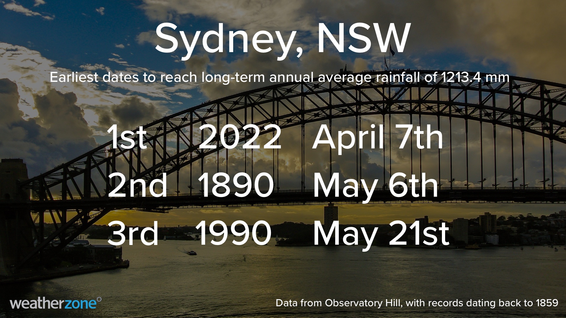 Sydney this year should be admitted to a mental asylum. She is not okay. These "rain bombs" just ain't stopping...Lol. |
|
|
|
Post by srfoskey on Apr 6, 2022 20:48:54 GMT -5
We got a good soaking rain on Monday, but the humidity was quite low today, with a fire risk in the panhandle. Yesterday it was 80°F (27°C) with a dewpoint of 52°F (11°C), and it was the first real warmth and humidity I've felt this season. It's pretty mild on a broad scale, but my body has adjusted to dry weather the past several months.
|
|
|
|
Post by greysrigging on Apr 7, 2022 4:40:11 GMT -5
|
|
|
|
Post by Ariete on Apr 7, 2022 5:50:30 GMT -5
7th day of April and we still haven't even hit a 5C high.  |
|
|
|
Post by rozenn on Apr 7, 2022 6:23:45 GMT -5
No above average high here so far, which is a refreshing (pun intended) in a sea of above normal temps. Nice looking squall line on the radar: 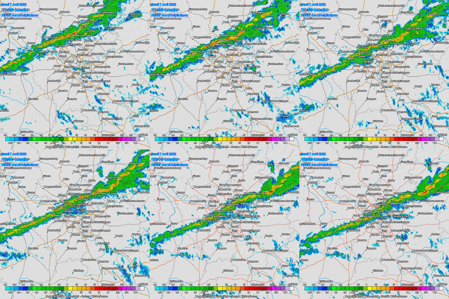 Some nice rain tomorrow hopefully! 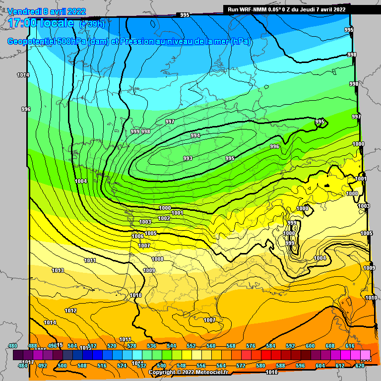 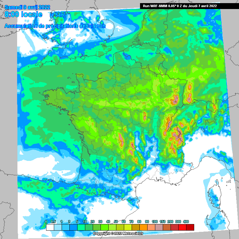 Very localized temperature gradient thanks to the shape of the low pressure area. Would have been awesome in winter... 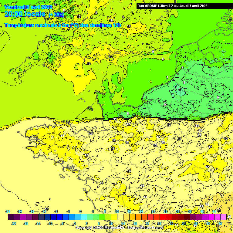 This model predicts a snowstorm lol. 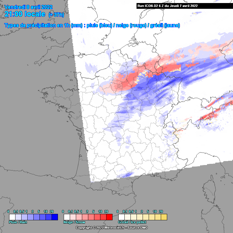 |
|
|
|
Post by aabc123 on Apr 7, 2022 14:39:34 GMT -5
Cloudy and mostly rainy but there was no wind and it was milder, high 9.4c, low -0.2c, so a better day than yesterday.
|
|
|
|
Post by Steelernation on Apr 7, 2022 18:59:32 GMT -5
McAllen, Texas reached 109 f (43 c) yesterday! A new April record high and set very early in the month.
3rd straight dry, sunny, windy day here. The wind has gotten quite old. Very consistent 30-40 mph gusts which is quite annoying and unpleasant but too low for interest.
|
|
|
|
Post by Crunch41 on Apr 7, 2022 22:50:45 GMT -5
I was looking at the McAllen temp and started looking back through the country's hottest places by date. It was showing a bunch of 100F readings in January, so I started this post. Those were some kind of error...but Falcon Lake RAWS reached 99F on January 1st! Nearby Falcon Dam reached 97 on the 2nd, so maybe that's 1 day behind. The earliest 100F was 101 at Falcon Lake on February 22nd. Falcon Lake and Rio Grande City are the two main hot spots to look at. All three of these stations have seen several days in the high 90's and it's just getting to the hot time of the year. The hottest temp for yesterday was not those spots. It reached 111F in the outskirts of McAllen (8 miles southeast of Pharr). According to Wikipedia, the record high for Pharr is only 110...but I don't know how long the POR is. McAllen has a record high of 111F. Reynosa across the border is also 44C/111F. Their record high is in March, which is a very odd month to have a record high. www.wpc.ncep.noaa.gov/archives/web_pages/discussions/archive_nathilo.php?adate=04/01/2022&sdate=20220313 en.wikipedia.org/wiki/Pharr%2C_Texas |
|
|
|
Post by rozenn on Apr 8, 2022 6:24:33 GMT -5
Large temperature contrast over the region as predicted:  20 mm so far, a great day for the thirsty spring vegetation. Evening snow would be a silver lining. |
|
|
|
Post by Morningrise on Apr 8, 2022 7:16:26 GMT -5
18C high in the forecast today! Damn that's gonna feel nice! Unfortunately we're plummeting back to winter temperatures for the coming week so that'll be a bit rough, but it looks like we're headed back to seasonal conditions again after that so hopefully the cold snap will be short lived.
|
|
|
|
Post by rozenn on Apr 8, 2022 9:00:44 GMT -5
Rainfall's turning convective with on and off downpours as the airmass conflict zone is moving a bit northwards towards us. Large temp spread in the area, with low 60s & convective rainfall in the southern outskirts vs high 30s & sleet in the NW outskirts. Mid to high 70s in parts of the south!  Edit: impressive shear here as the rain has temporarily cleared near the heart of the low. Low-level clouds move swiftly towards the west whereas mid-altitude clouds do the contrary. Storms are appearing southeast of here on the lightning map, so funnel clouds are likely to form over there.  EDIT: 40 mm here! And as a silver lining, the largest snowflakes I've seen in a while to end an awesome day weather-wise. The white stuff temporarily stuck in parts, like here in Montmorency forest in the NW suburbs (photo from neige95 on Infoclimat):  |
|
|
|
Post by Ariete on Apr 9, 2022 13:17:50 GMT -5
39.3 mm of precipitation has fallen so far in April. While at first glance it doesn't seem that much, April is our driest month with an average of 33 mm. So above normal with only 9 days in. The wettest during the last normals was April 2006 with 60 mm, so that can easily be beat.
|
|
|
|
Post by rozenn on Apr 9, 2022 20:05:15 GMT -5
47.2 mm here, almost reaching the monthly mean, including yesterday's 40 mm. Early spring was warm and dry and there's no rain in sight tho, so all that precipitation was definitely needed. Temp graph from a weather station in the southern outer suburbs yesterday. One can see a brief warm spike when that location was temporarily located on the warm side of the temperature gradient. This contrasts with the NW outer suburbs, which maxed out around 6-7°C. 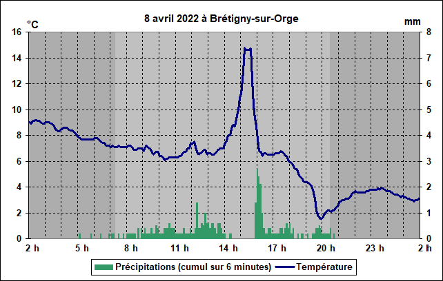 |
|