|
|
Post by ral31 on Apr 9, 2022 20:40:48 GMT -5
Tornado outbreak earlier this week in GA & SC. It's been quite active the past few weeks across the Southern U.S. Another tornado outbreak possible this coming week with the Plains at risk Tuesday and shifting eastward Wednesday. Tornado reports so far this year. My area is in a gap. Central MS & AL are covered with reports.  |
|
|
|
Post by greysrigging on Apr 9, 2022 21:21:05 GMT -5
A classic Great Australian Bight westerly cold front as seen in the Charts and on the Radar. Another secondary system passing clipping the south west corner of Western Australia.      Note how warm Hobart is for an April 10th day ( just prior to the cold front sweeping in from the West. )  These westerly frontal systems often cause substantial max temp drops as can be seen in the forecasts for Melbourne and Hobart. Much of the southern coast of Victoria is experiencing April max temps 6c-8c above average, but with the passing of the front, max temps will be about 10c cooler tomorrow Note the Adelaide ir far enough north and west to miss the cooler air. Hobart.   Melbourne.  Adelaide.  |
|
|
|
Post by Beercules on Apr 9, 2022 22:06:30 GMT -5
thank god we'll miss the gay polar bullshit
31C here atm. Adelaide had a 19.4C low, but merely 12C here
|
|
|
|
Post by Ethereal on Apr 9, 2022 22:18:00 GMT -5
A classic Great Australian Bight westerly cold front as seen in the Charts and on the Radar. Another secondary system passing clipping the south west corner of Western Australia.  These westerly frontal systems often cause substantial max temp drops as can be seen in the forecasts for Melbourne and Hobart. Much of the southern coast of Victoria is experiencing April max temps 6c-8c above average, but with the passing of the front, max temps will be about 10c cooler tomorrow Note the Adelaide ir far enough north and west to miss the cooler air. These westerly frontal systems on the Bight are gratifying and much longed-for, as they tend to get foehn'd over the Ranges and thus give us mild sunny conditions. We really need more of those now. The stubborn High(s) on the Bight and in the Tasman Sea have directed those devastating & persistent rainfalls over us. They have been the cause of this dank weather. Let's hope the westerly frontal systems defeat those blocking highs in the south and push them off for good!  The arrival of these westerly frontal systems remind me of the Forth Eorlingas scene in Lord of the Rings... Hehehe  |
|
|
|
Post by Beercules on Apr 10, 2022 1:25:57 GMT -5
I certainly don't long for that cancer.
|
|
|
|
Post by Giorbanguly on Apr 10, 2022 5:03:29 GMT -5
Uljin on the East Coast reached 30C yesterday! Weird location for being the epicenter of a spring heatwave; it's in the northern half of the country AND it's right on the coast  |
|
|
|
Post by rozenn on Apr 10, 2022 5:22:00 GMT -5
Cold morning.  Uljin on the East Coast reached 30C yesterday! Weird location for being the epicenter of a spring heatwave; it's in the northern half of the country AND it's right on the coast Prolly foehn winds? |
|
|
|
Post by Giorbanguly on Apr 10, 2022 5:34:50 GMT -5
Could be Foehn winds yes. There are some mountains just to the west of that location
And damn, that one Paris station is like a fortress in the sea of blue
|
|
|
|
Post by rozenn on Apr 10, 2022 6:11:12 GMT -5
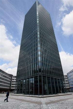
Could be Foehn winds yes. There are some mountains just to the west of that location And damn, that one Paris station is like a fortress in the sea of blue It's not Montsouris though (1.9°C there), but a station right in the city center, so obviously warmer. These stations tend to be ridiculously warm at night. Well in fact that station is on the top of this highrise, not really a good comparison with rural settings lol:  The city center is really almost that warm though, a station located in an admittedly small lawn, but at least at ground level at Lariboisière hospital recorded a 5.8°C low. On the opposite side of the spectrum, the coldest station inside Paris was Longchamp racecourse in the Bois de Boulogne, a few kilometers from the Eiffel tower, with -3.1°C. Lots of microclimates in the city, you can feel a huge diff entering large parks at night when it's still. |
|
|
|
Post by Doña Jimena on Apr 10, 2022 8:26:03 GMT -5
6 lightning strikes on Riga in the middle of the day:   |
|
|
|
Post by ilmc90 on Apr 10, 2022 9:39:03 GMT -5
Spent the entire day outside yesterday at a local campground. It was around 45 F/7 C and raining all morning but then had some breaks of sun in the afternoon and the temperature warmed into the 50s. Still had some intermittent showers and even some hail during the afternoon. Somewhat bipolar weather as it would be sunny and then dark clouds quickly rolled in with a chilly wind and it would start raining again. Then it would stop and start clearing up. High/low ended up being 54 F/42 F (12 C/6 C).
Similarly raw conditions today with some breaks of sun but still a chilly wind and a chance for showers.
|
|
|
|
Post by Steelernation on Apr 10, 2022 12:05:40 GMT -5
Got to 78 (26 c) yesterday, which could end up being the warmest temp of the month.
The next 2 weeks are shaping up to be cold, but not interestingly so with lots of 40s/50s highs. Wednesday’s snow has been downgraded to just a chance and if it falls there probably won’t be much.
This is shaping up to be the first bad month weather-wise since I moved here with cold but boring temps, little if any snow and no storms, variability or anything of interest.
|
|
|
|
Post by Benfxmth on Apr 10, 2022 18:00:50 GMT -5
Rather chilly today, with a high of 61.5°F (16.4°C) at my PWS today in spite of sunny skies. Looking to warm back up for most of next week, with a forecast high tomorrow of 79°F (26°C) here followed by forecast highs in the 80-83°F range for Tuesday-Thursday as high pressure to the south shifts eastwards. A cold morning today, with lows in the 30s in SC & Georgia last night...  |
|
|
|
Post by Ethereal on Apr 10, 2022 19:50:14 GMT -5
I certainly don't long for that cancer. Understandable. Considering that you guys are windward.  |
|
|
|
Post by Crunch41 on Apr 10, 2022 19:50:21 GMT -5
Jets has mentioned it in the shoutbox, but a huge snow storm is forecast in the plains this week. EC has 20-40cm for Winnipeg NWS has the highest snow totals landing near Bismarck, ND.  |
|
|
|
Post by greysrigging on Apr 10, 2022 19:53:08 GMT -5
The change in temperatures after the passing of a strong westerly frontal system through the Great Australian Bight.  Eucla  |
|
|
|
Post by greysrigging on Apr 11, 2022 3:15:58 GMT -5
An interesting expanation of this season's La Nina in Australia. www.weatherwatch.net.au/2022floods?fbclid=IwAR1q1g2LOmRkTyKqxIibPJBSFVHNkoOK0BWd9W4MvG2AsfN5cAELUa8kx7M^^From MeteorologistAnthony Cornelius "What causes some La Nina's to be so severe? "A La Nina within a La Nina" - understanding the Pacific Decadal Oscillation There's been plenty of discussion about why we've seen such incredible rainfall and flooding in eastern NSW and southeast Queensland during the last 1-2 months. Most of it revolves around the current La Nina - however La Nina's are not rare by any means. So why are some La Nina's relatively benign, but others like 2022, 2011, 1974 and even 1893 so destructive? While a part of this comes down to chance, there is another oscillation that can sync in with La Nina's and El Nino's to enhance or weaken them called the Pacific Decadal Oscillation. For those interested in a more in depth look at what has made 2022 exceptional, have a look at the article we've posted online. |
|
|
|
Post by Ariete on Apr 11, 2022 4:14:22 GMT -5
Summary of the first 10 days of April 2022, and deviations from the 91-20 normals for the first 10 days: Avg high: 3.6C (-3.0C) Mean: -0.1C (-2.8C) Avg low: -3.8C (-2.6C) Precipitation: 40.6mm (+31mm) No day so far has reached the normal average high, and as a whole this is the 4th coldest start to April since 1991.  |
|
|
|
Post by Morningrise on Apr 11, 2022 8:27:47 GMT -5
It's mid-April, and what did I wake up to this morning? Snow. Snow everywhere! And with sub-freezing highs in the forecast until the weekend and lows near -10C it looks like it'll be sticking around. It's not unusual to have a snowfall this late in the season, but it is quite rare for it to stick around for more than a day or so. Good thing my car still has its winter tires on!
|
|
|
|
Post by Morningrise on Apr 11, 2022 17:16:51 GMT -5
There's a massive blizzard on its way to southern Manitoba and southeastern Saskatchewan on Tuesday night and Wednesday. Apparently it has the potential to be the worst blizzard in decades in the area, with the possibility of 30 to 50 cm of snow in the southeastern corner of the province. Even Regina is expecting 10 to 20 cm, though thankfully Saskatoon seems to be out its path so far and is not expected to be affected. This will be one to watch for sure.
|
|