|
|
Post by 🖕🏿Mörön🖕🏿 on Nov 22, 2018 17:33:29 GMT -5
nice weather in Halifax, NS right now.
13F snow and 21 mph winds.
|
|
|
|
Post by Steelernation on Nov 22, 2018 18:06:35 GMT -5
Rochester only reached 19 (-7 C) today! Thats the lowest November high since 1936 and the T-5th coldest overall!
The low this morning was 10 (-12 C) and it will probably get colder tonight.
Cleveland was a bit milder, with temps in the high 20s much of the day.
|
|
|
|
Post by nei on Nov 22, 2018 22:05:15 GMT -5
Looks like Massachusetts and upstate NY have the biggest departures from normal by daily highs, but I'm not sure exactly. Bigger difference between coast and inland her. Wind is calming down up there; will be interesting to see who hits below 0°F. Really dry airmass here, Northeast stands out.  Mount Washington recorded its coldest temperature early this morning and it'll slowly warm overnight, arctic air is already starting to weaken aloft even if the coldest low elevation temperatures will be tomorrow morning from radiational cooling. Weird mismatch of temperatures from the Observatory site and the NWS reporting from the station. If the NWS reporting of -26°F this morning is correct, then it broke the previous November record of -20°F. Graph makes it look like the coldest temperature was -20°F but odd why the dewpoint didn't match; usually it's at near 100% with cold air. Observatory post says -26°F, something is wrong with their readout on their site and -26°F must be the real low. Observatory graph  I think the temperature line should be where the dewpoint line is. NWS hourly report has 100% humidity the entrire  |
|
|
|
Post by nei on Nov 22, 2018 22:09:57 GMT -5
today's maxes. Big drop going north from Long Island/NYC  |
|
|
|
Post by nei on Nov 22, 2018 22:16:24 GMT -5
Ben Lomond, a 2500 feet (800 m) mountain near San Francisco got 3 inches of rain in one day yesterday. Air switched from dry continental (bringing wildfire smoke) to moist pacific as the rain came in. Rather big dewpoint swing.  |
|
|
|
Post by nei on Nov 22, 2018 22:20:41 GMT -5
at the peak of the cold; very chilly 850 mb temperatures  Saturday night cold air will be all gone  And a rainstorm with 1-2 inches of rain will come with the mild air  Saturday's mild air will precede the rain and Sunday will be similar temperature-wise. Is it a front? Right now that same rain system is in the Midwest, looks much weaker, maybe getting wetter once it taps into Atlantic moisture? Or the temperature contrast fuels it? California's first rainstorm (and snowstorm in the mountains) is occurring right now.  |
|
|
|
Post by nei on Nov 22, 2018 22:28:30 GMT -5
looks like Saturday night's rains doesn't fall under a typical cold or warm front. Warm air floods in as the arctic air mass leaves, and then a coastal low goes up the coast after it exits  check out the fronts tab www.wpc.ncep.noaa.gov/#page=frt |
|
|
|
Post by Ariete on Nov 23, 2018 8:23:06 GMT -5
New cold record for the season yesterday: -6.0C.
|
|
|
|
Post by Steelernation on Nov 23, 2018 10:04:18 GMT -5
Yesterday dropped to 7 (-14 C), a new daily record.
Then this morning upstaged that, falling to 4 (-16 C)!
In addition to another daily record it is the
•2nd coldest November temp on record
•Coldest November temp since 1875
This was an epic cold snap!
|
|
|
|
Post by bizzy on Nov 23, 2018 16:03:25 GMT -5
Dropped down to 15°F (-9.7°C) this morning, crazy for November. Colder than my lowest recorded temperature for the entirety of Winter 2016-17 (16°F).
|
|
|
|
Post by AJ1013 on Nov 23, 2018 17:11:20 GMT -5
Low to mid-60’s and sunny today.  |
|
|
|
Post by Babu on Nov 23, 2018 17:16:23 GMT -5
What a fascinating sky. I never saw a sky like that in Sweden. A lot of fall colors. Where is it?
|
|
|
|
Post by Lommaren on Nov 23, 2018 17:32:11 GMT -5
What a fascinating sky. I never saw a sky like that in Sweden. A lot of fall colors. Where is it? He's in Nogales, Arizona. I'm surprised by how flush it is given its semi-arid nature, completely dependent on a brief summer rain season. |
|
|
|
Post by AJ1013 on Nov 23, 2018 17:33:30 GMT -5
What a fascinating sky. I never saw a sky like that in Sweden. A lot of fall colors. Where is it? That’s in Madera Canyon at the base of Mt Wrightson. en.m.wikipedia.org/wiki/Madera_Canyon |
|
|
|
Post by Lommaren on Nov 23, 2018 17:34:19 GMT -5
That’s in Madera Canyon at the base of Mt Wrightson. So you've already travelled away from Nogales? Or is that the same county/area? |
|
|
|
Post by AJ1013 on Nov 23, 2018 17:35:39 GMT -5
That’s in Madera Canyon at the base of Mt Wrightson. So you've already travelled away from Nogales? Or is that the same county/area? It’s about 40 minutes north of Nogales. Went there to hike. |
|
|
|
Post by Babu on Nov 23, 2018 17:42:57 GMT -5
2nd ice day in a row by a 0.1'C margin. 0.0'C high, and 0.1'C is the SMHI requirement.
|
|
|
|
Post by nei on Nov 23, 2018 22:21:38 GMT -5
2nd ice day in a row by a 0.1'C margin. 0.0'C high, and 0.1'C is the SMHI requirement. We just had two ice days in a row. We matched! |
|
|
|
Post by chesternz on Nov 23, 2018 23:56:07 GMT -5
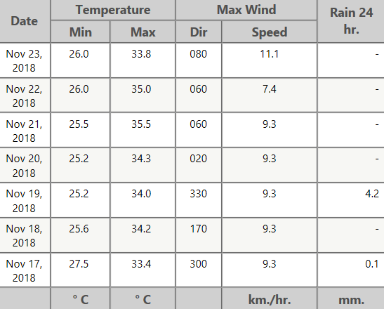
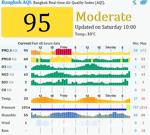
Another hot week. Over 30 mm of rain downtown but far more modest amounts elsewhere. Bright blue skies are sadly still not a common sight - it's mostly either cloudy or hazy. Still a bit of thunder and lightning here and there.  Air quality is on the slide with some worrying PM2.5 figures:  |
|
|
|
Post by Cadeau on Nov 24, 2018 0:51:31 GMT -5
Seoul saw first snow day this morning(24th) and total accumulation was 8.8 cm, the highest amount first snow day of the season since 1981 when the observation began to recording detail about the first snow-related measurement. According to the KMA, the previous record before today was 4.5 cm received in 1990. There were many years in count having no record of snowfall in the first time of the season because it tends to rain and snow mixed together and did not accumulate on the ground.  |
|