I've found a quite interesting article about the weather of the last few weeks around my area, which was really uncommon for this period of the year. At first I wanted to use google translate and to just post you the link to the translated webpage, but then I noticed that the automatic translation messed up also with the meaning of the article itself. So here there my translation:
7th-9th of January 2018: hot sirocco wind, record rain and avalanches on western AlpsAuthor: Società meteorologica italiana / Editoriale Nimbus - January 10, 2018
Original link:
hereThe period between late December 2017 and early January 2018 was very mild and humid in the Alps, characterised in a first stage by Atlantic storms with strong westerly winds, heavy rainfall and avalanches in areas bordering France and Switzerland (days from December 27th to January 4th). Following, an intense sirocco that caused a marked barrier from the south-east, record rain especially on the relieves around Turin, abnormally high temperatures, heavy snowfalls (but only above 1400 - 1700 m), and other avalanches (7th-9th January).
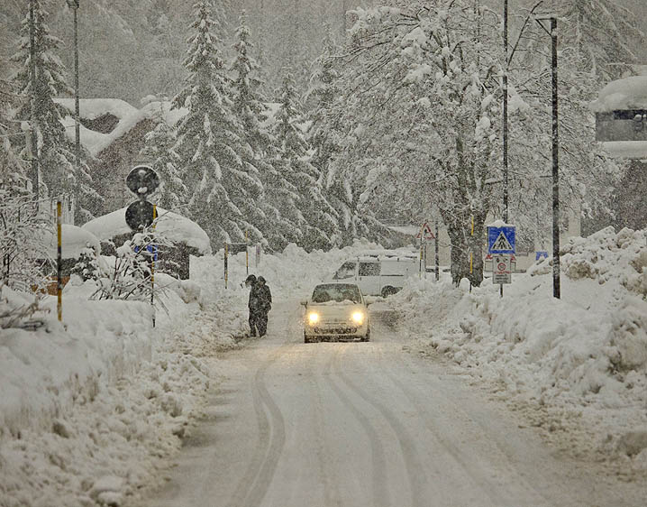 Gressoney-La Trinité (1650 m, Monte Rosa) under a intense snowfall associated with sirocco wind, 8th of January 2018. At lower altitudes precipitations occurred almost entirely in rainy form, with more autumn or spring characteristics
than winter (picture by Roberto Cilenti).In Turin the first week of January 2018 was the warm start of the measures in 1753, with an average temperature of 6.8 ° C (3.8 ° C above normal). In recent years very similar cases were recorded in 2013 (Tmed 6.4 ° C) and 2015 (6,7 ° C), confirming the pressing upward trend in winter temperatures.
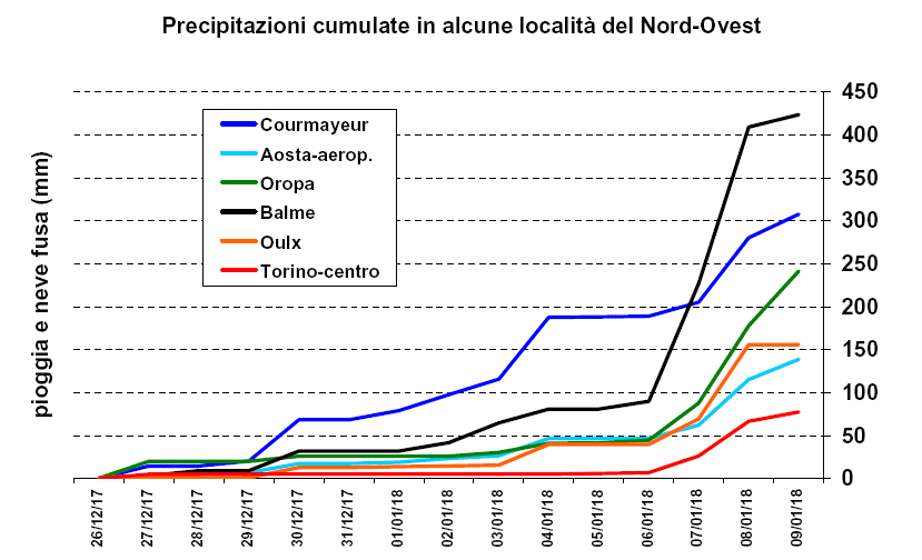 The frequent rainfall that continued from the 27th of December 2017 to the 9th of January 2018, at first the most intense on the border areas with France and Switzerland, and then closer to Piedmont plain, totaled: 77 mm in Turin-center,
139 in Aosta-Airport , 156 in Bardonecchia, 241 in Oropa, 307 in Courmayeur and 423 mm in Balme.1 to 4 January 2018: storms from west, rain at 2000 m
and avalanches on the border areasIn early 2018, as early as the end of December 2017, ongoing disruption from the Northwest have made the weather really dynamic: the most abundant rainfall have affected the mountains bordering France and Switzerland, where sometimes the rain-snow limit is rose to above 2000 m, anomalous situation that in recent winters we observe more and more often.
In particular the station of
Courmayeur -Dolonne (network Aosta Functional Center Reg. ) Received 187 mm of rain and melted snow from December 27 to 4 January, rare amount for the area.
(*note: that place is at about 1200 m of altitude, at the base of the Mount Blanc)
in the morning of January 4 in
Cervinia (altitude 2000 m), the total snowpack touched 192 cm, and the precautionary closure of the road to the danger of avalanches isolated ten thousand tourists until the morning of the 5th.
In the high Susa Valley, always on day 4, a large avalanche grazed
Rochemolles (a part of the municipality of Bardonecchia at 1600 m of altitude), causing the complete evacuation.
(note: the inhabitants of Rochemolles were allowed to return to their home yesterday)
Degna di nota inoltre la violenta tempesta di vento da Ovest che il 3 gennaio ha fatto registrare velocità fino a 200 km/h sulle creste più elevate
Another remarkable phenomenon is the strong western wind storm which, in January 3rd, reached a windspeed of 200 Km/h on the highest peaks (as recorded by the weather station in Gran Vaudala, 3272 m of altitude, in the
Gran Paradiso national park).
 Aerial picture of the avalanche close to the village of Rochemolles, from link
7th - 9th January 2018: warm and stormy sirocco wind,
exceptional rain and thunderstorms for the alpine winter,
lots of snow only at high altitudesDuring the first few days of 2018 the areas at low and middle altitudes in the Piedmont valleys received modest amounts of rain because of NW air currents. Between the 7th and the 9th of January instead strong and humid sirocco winds from SE, associated with the Mediterranean low pressure area "Dora", generated intense and long-lasting precipitations, exceptional for the winter months which are usually colder and much drier.
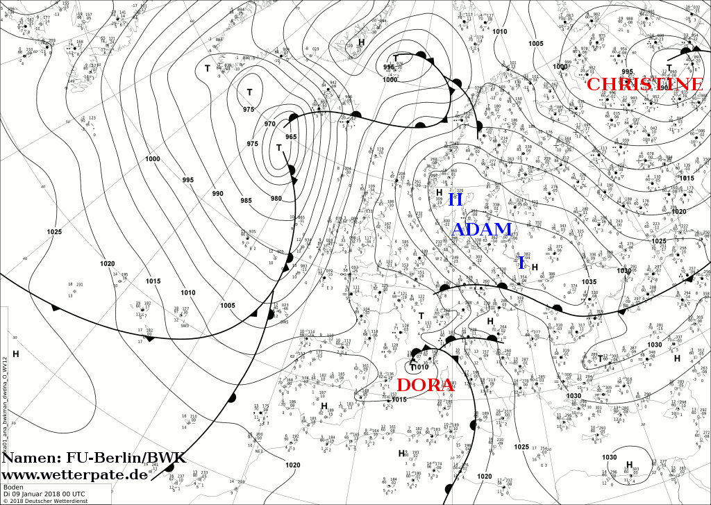
Pressure Analysis and fronts at 00 h UTC on January 9, 2018: The "Dora" depression in front of the French Riviera pushes a strong south wind to the Alps, while the approaching cold front, evolving in occluded front over Piedmont determines unusual winter storms (source:
Institute of Meteorology, University of Berlin ).
As usually happens with SE winds, the greatest amount of precipitation (total> 200 mm) fell on the relieves near Turin, the Aosta Valley and the Eastern
Ossola valley, with peaks above of 350 mm on the
Lanzo valleys and on the lower part of thevalley of the
Lys valley and
Val Sesia (in
Pian Audi, 464 mm of rain were recorded between the 6th and 9th of January ).
These amounts of rain are completely unheard for the winter, while this weather pattern is common during a great rainy episode in October-November or April-May.
For example, in
Balme (1450 m, Lanzo Valleys), a place that has a complete pluviometric series since 1914, 319 mm of rain and melted snow fell in the 48 hours between the h 8 January 7th and H 8 of 9th January 2018, the value far exceeding the previous record winter of 185 mm measured at the same time interval between 8 h of the 14 th and 8 h of the 16th of December 2008.
Furthermore, it also exceeds the amount so far detected in all winter sequences up to 5 consecutive days (source: Gianni Castagneri from SMI, head of Balme weather station).
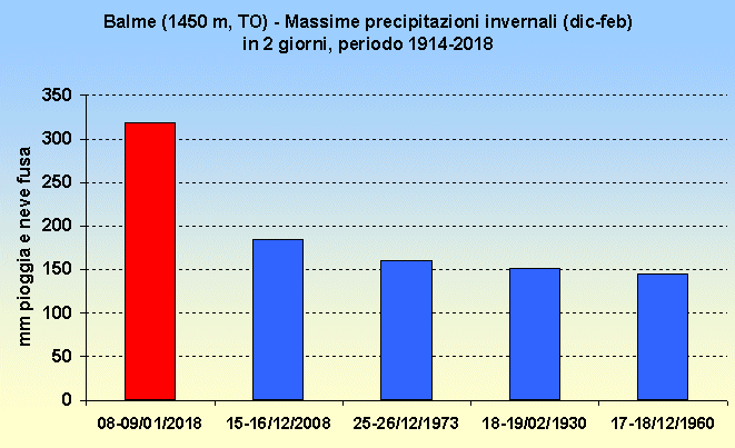 The five cases of more abundant precipitation in 2 days Balme in winter (December-February quarter) since 1914. The case of January 2018 is well above the previous highs.
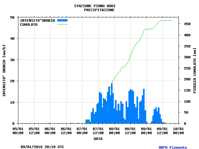 Hourly and accumulated rain between the 6th and the 9th of January in Corio - Pian Audi, center of the strong rain event. Total amount of accumulated rain: 464 mm.
The sirocco wind maintained particularly high temperatures for this season all over the period.
The minimum of 8.3 ° C recorded on Janauary 8th in Turin (weather station of Via della Consolata, ARPA Piemonte ) is one of the highest ever recorded in January in the absence of foehn wind in the city.
In addition, strong reinforcements of warm winds from the Mediterranean brought the temperatures up to 10°C also under the rain and at altitudes as high as 1000 m, as in the case of
Ala di Stura. The temperature showed really high fluctuations, depending on the strength of the warm wind and how much it managed to penetrate into the Alps area.
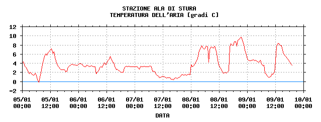 Temperatures in Ala di Stura (1006 m of altitude, Lanzo Valleys) between the 5th and the 9th of January. Source: Arpa piemonte
Snowfall was limited to the high altitudes, on average over the 1500-1700 m, and only above 2000 m precipitations were always in snow form allowing accumulation locally greater than 2 m in the Lanzo Valleys, in Lys valley and Valsesia. Similar snow amounts were recorded in December 2008, but in that case the abundant snowfall reached an altitude of about 1200 m.
The total height of snow on the ground at the end of event reached values sometimes quite unusual, such as 187 cm of
Salbertrand-Le Selle (1980 m of altitude, Val Susa, network ARPA Piemonte ), highest in the series since 1991, or 242 cm in
Cervinia (network CFR Valle d'Aosta ), probably a record for at least half a century, according to historical measures near the dam Cignana, just a higher altitude (2170 m).
The amount of snowfall increased the avalanche risk to level 5 (the highest on a European scale), between the Alps west of Turin and Mount Rosa. In the last decade such a large extension for the highest avalanche risk was observed only after the big snowfall in December 2008.
The evening of January 8 an avalanche hit an apartment building in
Sestriere (where the total snow on the ground reached 189 cm) without causing casualties or injuries, and other avalanches interrupted roads in the valleys of
Cogne (Epinel) and
Lys (Gressoney-St-Jean), as well as - on the French side -
Bonneval-sur-Arc, a village which remained isolated from the rest of the Maurienne.
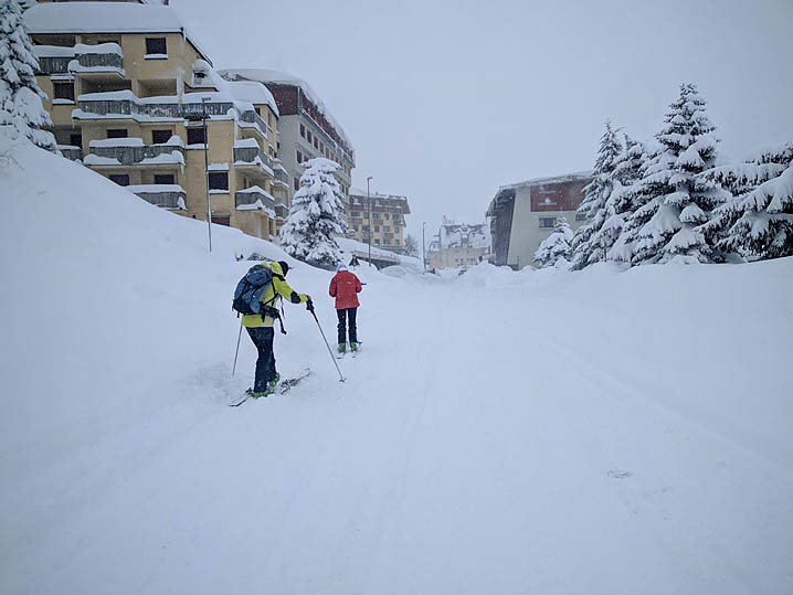
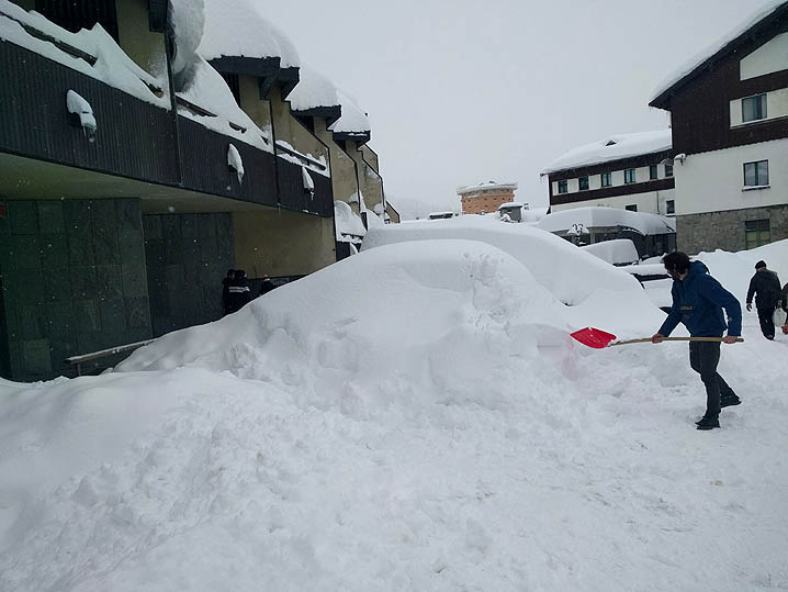
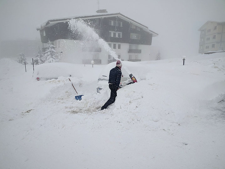 Pictures from Sestriere, Susa Valley. (source: ARPA Piemonte , photos Lucia Caretti / The Press)
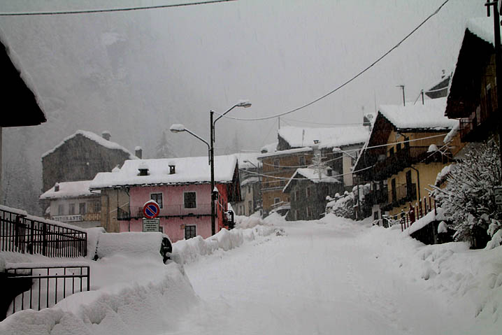
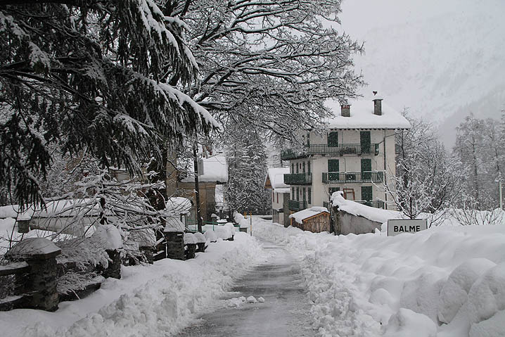 Pictures from Balme, Lanzo Valleys. (pictures by G. Castagneri)
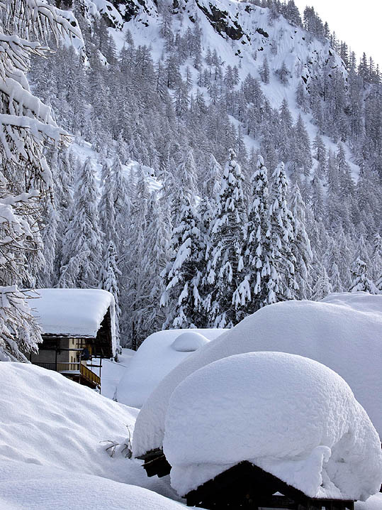 Picture from Gressoney (pictures from R. Cilenti)
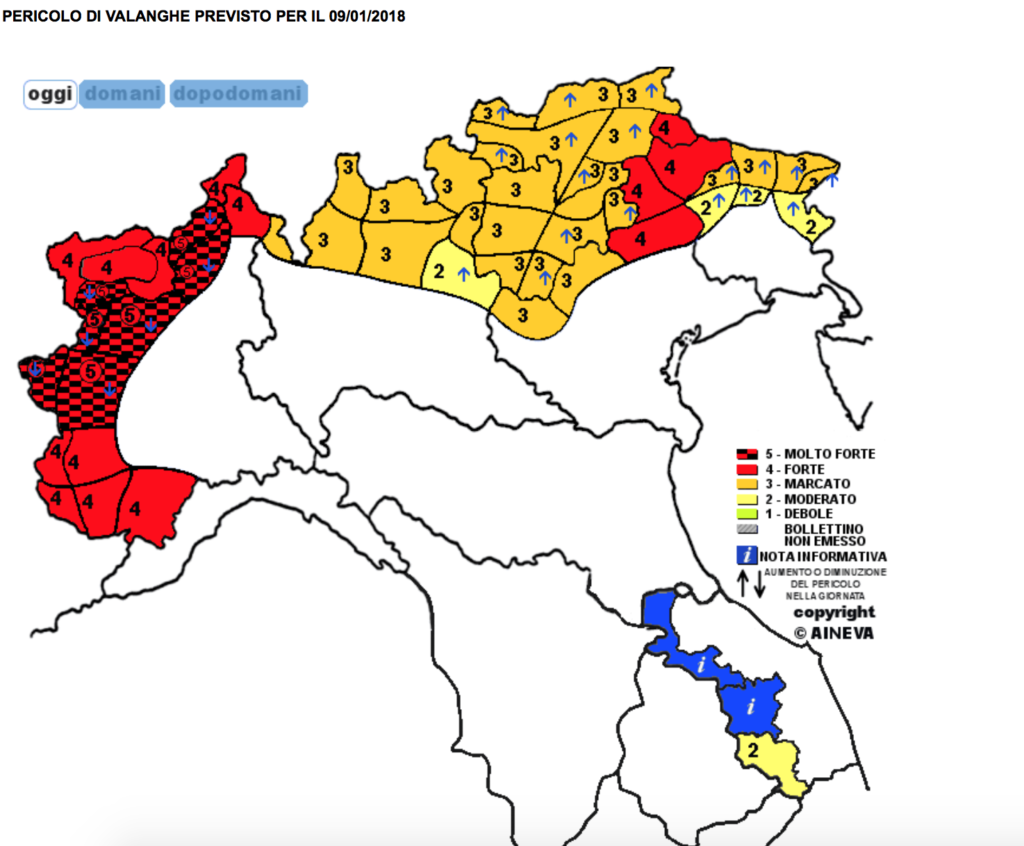 Map of the avalanches risk in the Alps for the 9th of January 2018 (AINEVA)
January 8, 2018: a memorably stormy evening
The evening of Monday 8 January will be remembered for its weather: with the passage of the cold front, the perturbed phase reached its climax on the northwest Italian with the formation of numerous thunderstorms, from the Ligurian Alps, the Turin area, to Ossola (and, further east, in Lombardy and in the Belluno the following day), with frequent lightning and thunder, pouring rain driven by gusts of warm south-east wind at 70-100 km / h in exposed valleys areas, sometimes even hail, snow blizzards only in high mountain , many alpine roads closed due to avalanches and watercourses close to the overflow limits in the valleys.
The occurrence of thunderstorm activity in the middle of winter in the Turin area is not quite exceptional because the other cases (often even with snow on the plains) occurred in January 28 1806, in January 21 1910 and January 12 1939. However the set of phenomena described above is unheard for this region during this season.
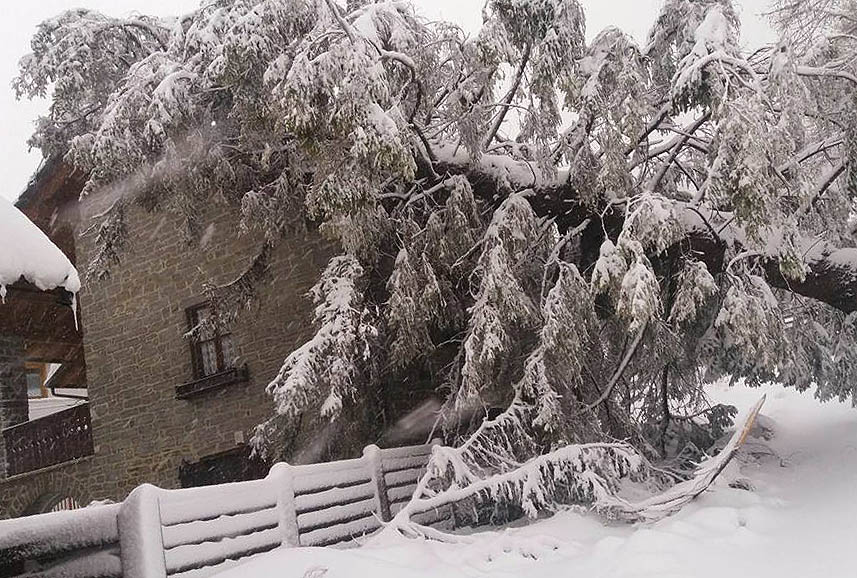 The strong wind caused damage too. Here a picture from Ceresole Reale (picture by M. Rolando)
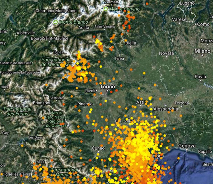 Map of lightning strikes recorded on NW Italy between h19 and h21 of the 8th of January 2018 (source)Warm records in Rome and Naples
In addition to precipitation out of the ordinary on the western Alps, the south wind made temperatures rise to extraordinary levels for January to central and southern Italy.
In particular, on January 8, Tmax of 20.2 °C was recorded in Rome-Fiumicino and 21.5 ° C in Naples-Capodichino, new records for the month in the series since 1959 and 1946 respectively.
Also of 24.1 ° C Palermo-Punta Raisi, lower than the historical record (25.6 ° C in January 1962), but still above average by 9 ° C.
Acknowledgments
Special thanks to G. Castagneri , member of SMI and scrupulous manager of the meteorological station of Balme (Lanzo Valleys), and all the authors who promptly sent photographs of the event in the newsroom.